IMAGES TAKEN NEAR TO
Agden, SHEFFIELD, S6 6JN
Introduction
This page details the photographs taken nearby to Agden, S6 6JN by members of the Geograph project.
The Geograph project started in 2005 with the aim of publishing, organising and preserving representative images for every square kilometre of Great Britain, Ireland and the Isle of Man.

There are currently over 7.5m images from over14,400 individuals and you can help contribute to the project by visiting https://www.geograph.org.uk
Image Map
Images are licensed for reuse under creativecommons.org/licenses/by-sa/2.0
Notes
- Clicking on the map will re-center to the selected point.
- The higher the marker number, the further away the image location is from the centre of the postcode.
Image Listing (7 Images Found)
Images are licensed for reuse under creativecommons.org/licenses/by-sa/2.0
Image
Details
Distance
1
Newly finished roadworks at Cowell House
Image: © John Slater
Taken: 6 May 2013
0.02 miles
3
Broken Rainbow
Rainbow at Rocher High Bradfield.
Image: © dave hudson
Taken: 5 May 2013
0.09 miles
4
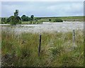
Bog cotton on Cowell Flat
Eriophorum angustifolium, commonly known as common cottongrass, bog cotton or common cottonsedge, is a species of sedge in the plant genus Eriophorum of the family Cyperaceae.
Image: © Neil Theasby
Taken: 1 Jul 2013
0.19 miles
5
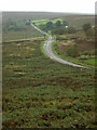
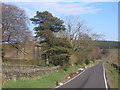
Penistone Road
Looking to Cowell Flat.
Image: © Alan Murray-Rust
Taken: 19 Sep 2008
0.21 miles
6
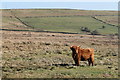
Highland Cattle
Highland Cattle, near Bradfield, South Yorkshire.
Image: © Dave Pickersgill
Taken: 9 Mar 2014
0.21 miles