IMAGES TAKEN NEAR TO
S6 6HS
Introduction
This page details the photographs taken nearby to S6 6HS by members of the Geograph project.
The Geograph project started in 2005 with the aim of publishing, organising and preserving representative images for every square kilometre of Great Britain, Ireland and the Isle of Man.

There are currently over 7.5m images from over14,400 individuals and you can help contribute to the project by visiting https://www.geograph.org.uk
Image Map
Images are licensed for reuse under creativecommons.org/licenses/by-sa/2.0
Notes
- Clicking on the map will re-center to the selected point.
- The higher the marker number, the further away the image location is from the centre of the postcode.
Image Listing (24 Images Found)
Images are licensed for reuse under creativecommons.org/licenses/by-sa/2.0
Image
Details
Distance
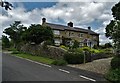
2
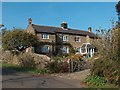
Lane junction in the hamlet of Ughill
A quaint hamlet and an unusual sounding place-name, likely to be of Scandinavian origin.
Image: © Jonathan Clitheroe
Taken: 1 Feb 2009
0.03 miles
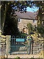
3
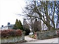
Ughill Hall
Gateway to Ughill Hall, with post box built into the stone wall adjacent.
Image: © Roger May
Taken: 5 Mar 2006
0.04 miles
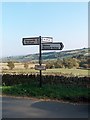
5
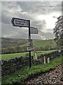
Signpost at the road junction in Ughill
I previously photographed this signpost in 2011: http://www.geograph.org.uk/photo/2630676
Image: © Neil Theasby
Taken: 10 Nov 2016
0.05 miles
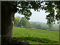
10
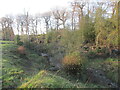
Wet Shaw Dike
Attractive little stream.
Image: © steven ruffles
Taken: 25 Nov 2020
0.13 miles