IMAGES TAKEN NEAR TO
Uppergate Road, SHEFFIELD, S6 6HJ
Introduction
This page details the photographs taken nearby to Uppergate Road, S6 6HJ by members of the Geograph project.
The Geograph project started in 2005 with the aim of publishing, organising and preserving representative images for every square kilometre of Great Britain, Ireland and the Isle of Man.

There are currently over 7.5m images from over14,400 individuals and you can help contribute to the project by visiting https://www.geograph.org.uk
Image Map
Images are licensed for reuse under creativecommons.org/licenses/by-sa/2.0
Notes
- Clicking on the map will re-center to the selected point.
- The higher the marker number, the further away the image location is from the centre of the postcode.
Image Listing (33 Images Found)
Images are licensed for reuse under creativecommons.org/licenses/by-sa/2.0
Image
Details
Distance
2
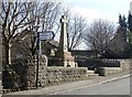
The war memorial in Stannington
It bears the names of local men who died in the two world wars.
Image: © Neil Theasby
Taken: 20 Mar 2015
0.04 miles
3
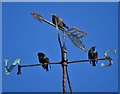
Three starlings on a weather vane
On the tower of Christ Church, Stannington
Image: © Neil Theasby
Taken: 13 Feb 2020
0.05 miles
4
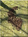
Beech nut husks on a gravestone
The gravestone in question contains several members of the Whittles famiy. They rest in the churchyard of Christ Church, Stannington.
Image: © Neil Theasby
Taken: 20 Mar 2015
0.05 miles
5
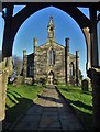
Christ Church, seen from the lychgate
The church was erected in 1830 under the auspices of the church of St Mary the Virgin, Ecclesfield.
Image: © Neil Theasby
Taken: 13 Feb 2020
0.06 miles
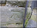
6
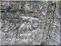
Cut Mark Christ Church Stannington
as above
Image: © Monica Stagg
Taken: 25 Feb 2015
0.06 miles
7
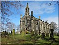
Christ Church in Stannington
Erected in 1830 under the auspices of the church of St Mary the Virgin, Ecclesfield.
Image: © Neil Theasby
Taken: 20 Mar 2015
0.06 miles
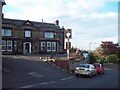
8
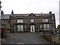
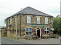
The Crown and Glove
The Crown and Glove (popularly known as The Top House) was at one time a cottage in a row of four, serving ale. It was then known as the Tontine and only from 1842 changed its name to The Crown and Glove.
Image: © DAVID M GOODWIN
Taken: 10 Nov 2009
0.06 miles
9
Cut Mark Outbuilding Crown and Glove Pub House
as above
Image: © Monica Stagg
Taken: 25 Feb 2015
0.07 miles
10
The Crown and Glove Public House
Public house, which according to the July 2012 issue of 'Beer Matters' (the newsletter of the Sheffield Branch of CAMRA) is likely to be only pub in the world with this name. It's situated on Upper Gate in Stannington occupying a prominent position overlooking the north west suburbs of Sheffield.
Image: © Jonathan Clitheroe
Taken: 9 Jun 2011
0.07 miles