IMAGES TAKEN NEAR TO
Dungworth, Bradfield, SHEFFIELD, S6 6HA
Introduction
This page details the photographs taken nearby to S6 6HA by members of the Geograph project.
The Geograph project started in 2005 with the aim of publishing, organising and preserving representative images for every square kilometre of Great Britain, Ireland and the Isle of Man.

There are currently over 7.5m images from over14,400 individuals and you can help contribute to the project by visiting https://www.geograph.org.uk
Image Map
Images are licensed for reuse under creativecommons.org/licenses/by-sa/2.0
Notes
- Clicking on the map will re-center to the selected point.
- The higher the marker number, the further away the image location is from the centre of the postcode.
Image Listing (7 Images Found)
Images are licensed for reuse under creativecommons.org/licenses/by-sa/2.0
Image
Details
Distance
1
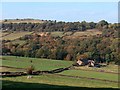
View to Broom Vale Farm from Corker Lane
Image: © Neil Theasby
Taken: 3 Oct 2011
0.01 miles
2
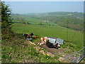
Cattle resting in the heat
High temperatures for April; Broom Vale Farm at the foot of the hill. Near Dungworth.
Image: © Peter Barr
Taken: 22 Apr 2011
0.14 miles
3
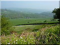
Farmland near Damflask Reservoir
Countryside to the west of Sheffield.
Image: © Peter Barr
Taken: 22 Apr 2011
0.18 miles
5
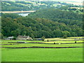
The view from Corker Lane
Damflask Reservoir in the Loxley valley can be seen in the distance.
Image: © Graham Hogg
Taken: 23 Aug 2011
0.21 miles
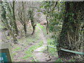
6
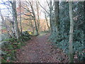
Footpath from Ughill wood lane.
Dropping down into the valley.
Image: © steven ruffles
Taken: 25 Nov 2020
0.21 miles
7
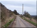
Ughill Wood Lane Looking East, Ughill Height
Image: © Terry Robinson
Taken: 7 Mar 2009
0.23 miles