IMAGES TAKEN NEAR TO
Storrs, SHEFFIELD, S6 6GY
Introduction
This page details the photographs taken nearby to Storrs, S6 6GY by members of the Geograph project.
The Geograph project started in 2005 with the aim of publishing, organising and preserving representative images for every square kilometre of Great Britain, Ireland and the Isle of Man.

There are currently over 7.5m images from over14,400 individuals and you can help contribute to the project by visiting https://www.geograph.org.uk
Image Map
Images are licensed for reuse under creativecommons.org/licenses/by-sa/2.0
Notes
- Clicking on the map will re-center to the selected point.
- The higher the marker number, the further away the image location is from the centre of the postcode.
Image Listing (6 Images Found)
Images are licensed for reuse under creativecommons.org/licenses/by-sa/2.0
Image
Details
Distance
3
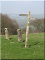
The way to go
A sign in a field. The gateposts indicate that this was once a boundary wall, but also that the wall is long gone.
Image: © Dave Pickersgill
Taken: 22 Mar 2012
0.16 miles
4
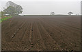
Ploughed field near Storrs
In recent years there have been more crops planted in the fields above the Loxley valley.
Image: © carol gill
Taken: 5 May 2008
0.22 miles
5
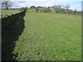
Footpath to Nether Cliffe and Hill Top
Image: © Chris Wimbush
Taken: 28 Mar 2010
0.23 miles