IMAGES TAKEN NEAR TO
Millwood View, SHEFFIELD, S6 6FG
Introduction
This page details the photographs taken nearby to Millwood View, S6 6FG by members of the Geograph project.
The Geograph project started in 2005 with the aim of publishing, organising and preserving representative images for every square kilometre of Great Britain, Ireland and the Isle of Man.

There are currently over 7.5m images from over14,400 individuals and you can help contribute to the project by visiting https://www.geograph.org.uk
Image Map (Loading...)


Getting Data...Please wait
Leaflet Map data © OpenStreetMap
Images are licensed for reuse under creativecommons.org/licenses/by-sa/2.0
Notes
- Clicking on the map will re-center to the selected point.
- The higher the marker number, the further away the image location is from the centre of the postcode.
Image Listing (8 Images Found)
Images are licensed for reuse under creativecommons.org/licenses/by-sa/2.0
Image
Details
Distance
3
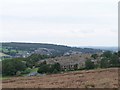
Footpath on the Brow of Acorn Hill
Public footpath which is seen here skirting the edge of Stannington. To the left is a steep wooded drop into the Loxley valley.
Image: © Jonathan Clitheroe
Taken: 2 Jun 2011
0.23 miles
4
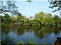
Olive House, Olive Mill Dam
On the River Loxley, one of several dams, near Stannington.
Image: © Peter Barr
Taken: 22 Apr 2011
0.23 miles
5
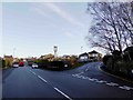
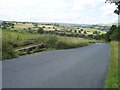
Junction to the Rose and Crown Inn on the right
Image: © Steve Fareham
Taken: 29 Dec 2015
0.23 miles
6
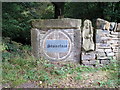
Sculpture in boundary wall
A local sculptor has recently purchased Storrs Wood in Loxley, Sheffield, and now displays some of his work within this beautiful location.
Image: © Graham Hogg
Taken: 23 Aug 2011
0.23 miles
7

The Spirit of Christmas
Christmas decorations on Stoors Lane, Stannington.
Image: © Dave Pickersgill
Taken: 3 Jan 2013
0.24 miles
8
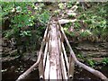
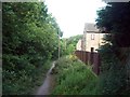
Footbridge across the River Loxley
This footbridge takes the footpath from the Stannington side of the Loxley Valley to the Loxley Road side.
Image: © Terry Robinson
Taken: 26 May 2008
0.24 miles