IMAGES TAKEN NEAR TO
Acorn Drive, SHEFFIELD, S6 6ER
Introduction
This page details the photographs taken nearby to Acorn Drive, S6 6ER by members of the Geograph project.
The Geograph project started in 2005 with the aim of publishing, organising and preserving representative images for every square kilometre of Great Britain, Ireland and the Isle of Man.

There are currently over 7.5m images from over14,400 individuals and you can help contribute to the project by visiting https://www.geograph.org.uk
Image Map
Images are licensed for reuse under creativecommons.org/licenses/by-sa/2.0
Notes
- Clicking on the map will re-center to the selected point.
- The higher the marker number, the further away the image location is from the centre of the postcode.
Image Listing (8 Images Found)
Images are licensed for reuse under creativecommons.org/licenses/by-sa/2.0
Image
Details
Distance
3
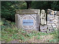
Sculpture in boundary wall
A local sculptor has recently purchased Storrs Wood in Loxley, Sheffield, and now displays some of his work within this beautiful location.
Image: © Graham Hogg
Taken: 23 Aug 2011
0.20 miles
4

The Spirit of Christmas
Christmas decorations on Stoors Lane, Stannington.
Image: © Dave Pickersgill
Taken: 3 Jan 2013
0.21 miles
5
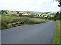
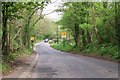
Junction to the Rose and Crown Inn on the right
Image: © Steve Fareham
Taken: 29 Dec 2015
0.23 miles
7

Stone carving at Storrs Woodland
This figure is part of a unique war memorial created by a sculptor known as Stoneface who works in Storrs Woodland.
Image: © Neil Theasby
Taken: 19 Feb 2018
0.24 miles
8
Rowel Bridge on Rowel Lane, Loxley Valley
Image: © Terry Robinson
Taken: 10 May 2008
0.25 miles