IMAGES TAKEN NEAR TO
Cliff Road, SHEFFIELD, S6 6EG
Introduction
This page details the photographs taken nearby to Cliff Road, S6 6EG by members of the Geograph project.
The Geograph project started in 2005 with the aim of publishing, organising and preserving representative images for every square kilometre of Great Britain, Ireland and the Isle of Man.

There are currently over 7.5m images from over14,400 individuals and you can help contribute to the project by visiting https://www.geograph.org.uk
Image Map
Images are licensed for reuse under creativecommons.org/licenses/by-sa/2.0
Notes
- Clicking on the map will re-center to the selected point.
- The higher the marker number, the further away the image location is from the centre of the postcode.
Image Listing (7 Images Found)
Images are licensed for reuse under creativecommons.org/licenses/by-sa/2.0
Image
Details
Distance
5
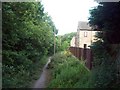
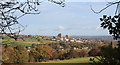
Footpath on the Brow of Acorn Hill
Public footpath which is seen here skirting the edge of Stannington. To the left is a steep wooded drop into the Loxley valley.
Image: © Jonathan Clitheroe
Taken: 2 Jun 2011
0.23 miles
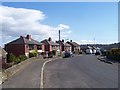
6
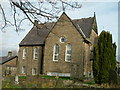
Knowle Top Methodist Church
The original church opened in 1822 but fell into disrepair. A new chapel was built in 1971 and this is the present building. However a fire in the 1990's made the main church building unsafe and services were held in the school-rooms.
Image: © DAVID M GOODWIN
Taken: 19 Nov 2009
0.24 miles