IMAGES TAKEN NEAR TO
Parkside Lane, SHEFFIELD, S6 6ED
Introduction
This page details the photographs taken nearby to Parkside Lane, S6 6ED by members of the Geograph project.
The Geograph project started in 2005 with the aim of publishing, organising and preserving representative images for every square kilometre of Great Britain, Ireland and the Isle of Man.

There are currently over 7.5m images from over14,400 individuals and you can help contribute to the project by visiting https://www.geograph.org.uk
Image Map (Loading...)


Getting Data...Please wait
Leaflet Map data © OpenStreetMap
Images are licensed for reuse under creativecommons.org/licenses/by-sa/2.0
Notes
- Clicking on the map will re-center to the selected point.
- The higher the marker number, the further away the image location is from the centre of the postcode.
Image Listing (7 Images Found)
Images are licensed for reuse under creativecommons.org/licenses/by-sa/2.0
Image
Details
Distance
1
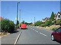
Oldfield Road, Stannington, Sheffield
Looking west.
Image: © JThomas
Taken: 30 Jun 2018
0.15 miles
2
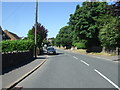
Oldfield Road, Stannington, Sheffield
Looking south west.
Image: © JThomas
Taken: 30 Jun 2018
0.17 miles
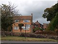
3
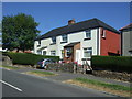
Houses on Oldfield Road, Stannington, Sheffield
Image: © JThomas
Taken: 30 Jun 2018
0.17 miles
4
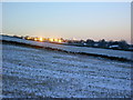
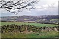
Early morning, Stannington
Early morning sun reflects off house windows in Stannington, Sheffield. View from footpath below Nethergate.
Image: © Brian Ward
Taken: 29 Dec 2005
0.18 miles
5
Junction of Church Street with Oldfield Road, Stannington
Image: © Neil Theasby
Taken: 23 Aug 2011
0.21 miles
6
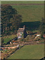
Cottage at Undertofts viewed from the opposite side of the Rivelin Valley
Image: © Neil Theasby
Taken: 11 Oct 2010
0.24 miles