IMAGES TAKEN NEAR TO
Riggs High Road, SHEFFIELD, S6 6DA
Introduction
This page details the photographs taken nearby to Riggs High Road, S6 6DA by members of the Geograph project.
The Geograph project started in 2005 with the aim of publishing, organising and preserving representative images for every square kilometre of Great Britain, Ireland and the Isle of Man.

There are currently over 7.5m images from over14,400 individuals and you can help contribute to the project by visiting https://www.geograph.org.uk
Image Map
Images are licensed for reuse under creativecommons.org/licenses/by-sa/2.0
Notes
- Clicking on the map will re-center to the selected point.
- The higher the marker number, the further away the image location is from the centre of the postcode.
Image Listing (28 Images Found)
Images are licensed for reuse under creativecommons.org/licenses/by-sa/2.0
Image
Details
Distance
2
Top of the Bank at Underbank
The white 'flowers' in the foreground are Rose Bay Willow Herb 'gone to seed' ... they looked very impressive.
Image: © Terry Robinson
Taken: 14 Sep 2008
0.06 miles
3
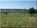
Silage field near Townhead Farm
West of Uppergate.
Image: © JThomas
Taken: 30 Jun 2018
0.08 miles
4
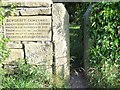
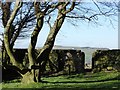
Plaque at the Entrance to Bowcroft Cemetery
Plaque and squeezer stile, beyond which is a well-maintained grove of trees and a path leading down to the burial site. Here there are a small number of 18th century graves all of which are nicely preserved. The headstones lie flat on the ground and some are cracked but the inscriptions are clearly legible.
Image: © Jonathan Clitheroe
Taken: 9 Jun 2011
0.12 miles
5
In Bowcroft Cemetery on Riggs High Road
This small but "ancient Quaker burial ground" contains the graves of members of the Shaw family of nearby "Hill" and "Brookside" farms. http://www.geograph.org.uk/photo/2452551
Image: © Neil Theasby
Taken: 13 Feb 2014
0.12 miles
6
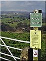
West of Stannington
Start of a public footpath that leads down to The Griffs from Riggs High Road.
Image: © Neil Theasby
Taken: 13 Feb 2020
0.14 miles
7
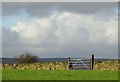
Field gate to Riggs High Road, Stannington
Viewed from Bowshaw Cemetery.
Image: © Neil Theasby
Taken: 24 Dec 2014
0.15 miles
9
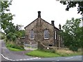
Underbank Day and Sunday School
Erected in 1855 and still looking in good condition.
Image: © Terry Robinson
Taken: 14 Sep 2008
0.17 miles
10
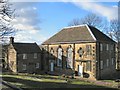
Underbank Unitarian Chapel
Chapel and cemetery at Underbank, founded in 1652, with the chapel consecrated in 1743. There is another building across the road which also resembles a chapel.
Image: © Roger May
Taken: 5 Mar 2006
0.18 miles