IMAGES TAKEN NEAR TO
Uppergate Road, SHEFFIELD, S6 6BX
Introduction
This page details the photographs taken nearby to Uppergate Road, S6 6BX by members of the Geograph project.
The Geograph project started in 2005 with the aim of publishing, organising and preserving representative images for every square kilometre of Great Britain, Ireland and the Isle of Man.

There are currently over 7.5m images from over14,400 individuals and you can help contribute to the project by visiting https://www.geograph.org.uk
Image Map
Images are licensed for reuse under creativecommons.org/licenses/by-sa/2.0
Notes
- Clicking on the map will re-center to the selected point.
- The higher the marker number, the further away the image location is from the centre of the postcode.
Image Listing (29 Images Found)
Images are licensed for reuse under creativecommons.org/licenses/by-sa/2.0
Image
Details
Distance
1
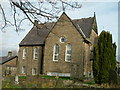
Knowle Top Chapel, Stannington
Opened in 1822, this Wesleyan chapel is also known simply as Stannington Methodist Church.
Image: © Neil Theasby
Taken: 20 Mar 2015
0.06 miles
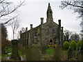
2
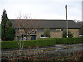
The Lomas Hall, Church Street, Stannington
The hall was opened in 1955 and presented to the village of Stannington in trust by Miss Flora Lomas. Today the hall is run as a charitable organisation and is managed by a voluntary committee made up of local people. The hall is the centre for many groups and activities.
Image: © DAVID M GOODWIN
Taken: 10 Nov 2009
0.06 miles
4
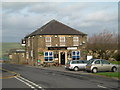
The Rose and Crown Stannington
The Rose and Crown has been known as "Minnies" by the locals.
During the year 1920 Mr and Mrs Irvine Lee took over the tenancy and after Mr Lee died in 1953, Mrs Minnie Lee carried on as a tenant for a number of years.
Image: © DAVID M GOODWIN
Taken: 19 Nov 2009
0.07 miles
5
Knowle Top Methodist Church
The original church opened in 1822 but fell into disrepair. A new chapel was built in 1971 and this is the present building. However a fire in the 1990's made the main church building unsafe and services were held in the school-rooms.
Image: © DAVID M GOODWIN
Taken: 19 Nov 2009
0.07 miles
6
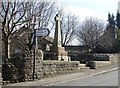
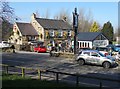
The war memorial in Stannington
It bears the names of local men who died in the two world wars.
Image: © Neil Theasby
Taken: 20 Mar 2015
0.08 miles
7

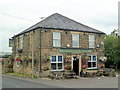
"The Rose & Crown" in Stannington
Still often known affectionately as "Minnie's" after a former landlady.
Image: © Neil Theasby
Taken: 20 Mar 2015
0.08 miles
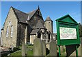
9
Christ Church, Stannington
This church was erected in 1830 as a chapelry to St Mary the Virgin, Ecclesfield
Image: © DAVID M GOODWIN
Taken: 10 Nov 2009
0.09 miles