IMAGES TAKEN NEAR TO
Katherine Road, ROTHERHAM, S66 9HF
Introduction
This page details the photographs taken nearby to Katherine Road, S66 9HF by members of the Geograph project.
The Geograph project started in 2005 with the aim of publishing, organising and preserving representative images for every square kilometre of Great Britain, Ireland and the Isle of Man.

There are currently over 7.5m images from over14,400 individuals and you can help contribute to the project by visiting https://www.geograph.org.uk
Image Map (Loading...)


Getting Data...Please wait
Leaflet Map data © OpenStreetMap
Images are licensed for reuse under creativecommons.org/licenses/by-sa/2.0
Notes
- Clicking on the map will re-center to the selected point.
- The higher the marker number, the further away the image location is from the centre of the postcode.
Image Listing (32 Images Found)
Images are licensed for reuse under creativecommons.org/licenses/by-sa/2.0
Image
Details
Distance
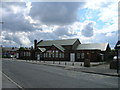
1
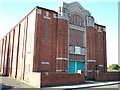
Former Woodhouse Green Wesleyan Methodist Chapel
Opened 1926, closed 1980s; sadly today with a partially bricked-up facade; now a sports hall.
Image: © emily gosse
Taken: Unknown
0.08 miles
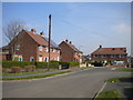
3
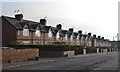
John Street, Thurcroft
Former coal board cottages.
Image: © Neil Theasby
Taken: 16 Nov 2012
0.09 miles
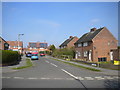
6
Eastern section of Rowena Drive, Thurcroft
Leading to a turning circle.
Image: © Richard Vince
Taken: 30 Mar 2019
0.11 miles
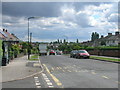
7
West end of Cross Street, Thurcroft
Seen from Central Drive.
Image: © Richard Vince
Taken: 30 Mar 2019
0.11 miles
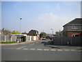
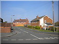
9
South end of Rowena Drive, Thurcroft
Seen from Katherine Road.
Image: © Richard Vince
Taken: 30 Mar 2019
0.12 miles
10
Scott Close, Thurcroft
Off Locksley Drive.
Image: © Richard Vince
Taken: 30 Mar 2019
0.13 miles