IMAGES TAKEN NEAR TO
Milton Street, ROTHERHAM, S66 8NE
Introduction
This page details the photographs taken nearby to Milton Street, S66 8NE by members of the Geograph project.
The Geograph project started in 2005 with the aim of publishing, organising and preserving representative images for every square kilometre of Great Britain, Ireland and the Isle of Man.

There are currently over 7.5m images from over14,400 individuals and you can help contribute to the project by visiting https://www.geograph.org.uk
Image Map
Images are licensed for reuse under creativecommons.org/licenses/by-sa/2.0
Notes
- Clicking on the map will re-center to the selected point.
- The higher the marker number, the further away the image location is from the centre of the postcode.
Image Listing (37 Images Found)
Images are licensed for reuse under creativecommons.org/licenses/by-sa/2.0
Image
Details
Distance
1
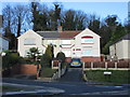
Houses on Rolleston Avenue
Typical of much of Maltby.
Image: © Jonathan Thacker
Taken: 8 Jan 2016
0.07 miles
4

St.Bartholomew's church, Maltby
A rather bland nave and chancel of 1859 but a Norman tower with a perpendicular top
Image: © Richard Croft
Taken: 19 Sep 2005
0.12 miles
5

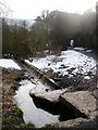
Shrine by Maltby Beck
Close to St Bartholomew's Church. Messages at the shrine indicate that the deceased was a woman. Did she drown in the beck? Was it suicide or a tragic accident? Whoever she was there's evidence that she was loved.
Image: © Neil Theasby
Taken: 18 Dec 2015
0.13 miles
7
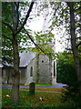
Tower of St Bartholomew's Church, Maltby
This tower was retained when the remainder of the church was rebuilt in 1859. It has masonry laid in a 'herring-bone' pattern generally considered to be a Saxon feature (see Image]).
Image: © Humphrey Bolton
Taken: 24 Oct 2015
0.15 miles
8
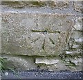
Ordnance Survey 1GL Bolt
This OS Bolt can be found on the west face of St Bartholomew's Church. It marks a point 85.146m above mean sea level.
Image: © Adrian Dust
Taken: 6 Jun 2016
0.15 miles
9
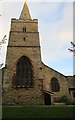
St. Bartholomew, Maltby
The tower of St. Bartholomew's church dates from the eleventh century as witnessed by the herringbone masonry. The spire is from the fifteenth century.
Image: © Jonathan Thacker
Taken: 8 Jan 2016
0.15 miles
10
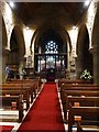
St Bartholomew's Church, Maltby - interior view
St Bartholomew's is a much loved and well-maintained village church with a Norman tower. It has recently undergone some thoughtful improvements - including the creation of toilets, wheelchair access and a small kitchen.
Image: © Neil Theasby
Taken: 18 Dec 2015
0.15 miles