IMAGES TAKEN NEAR TO
Rotherham Road, ROTHERHAM, S66 8ND
Introduction
This page details the photographs taken nearby to Rotherham Road, S66 8ND by members of the Geograph project.
The Geograph project started in 2005 with the aim of publishing, organising and preserving representative images for every square kilometre of Great Britain, Ireland and the Isle of Man.

There are currently over 7.5m images from over14,400 individuals and you can help contribute to the project by visiting https://www.geograph.org.uk
Image Map
Images are licensed for reuse under creativecommons.org/licenses/by-sa/2.0
Notes
- Clicking on the map will re-center to the selected point.
- The higher the marker number, the further away the image location is from the centre of the postcode.
Image Listing (53 Images Found)
Images are licensed for reuse under creativecommons.org/licenses/by-sa/2.0
Image
Details
Distance
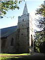
1

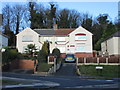
St.Bartholomew's church, Maltby
A rather bland nave and chancel of 1859 but a Norman tower with a perpendicular top
Image: © Richard Croft
Taken: 19 Sep 2005
0.08 miles
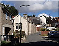
2
Houses on Rolleston Avenue
Typical of much of Maltby.
Image: © Jonathan Thacker
Taken: 8 Jan 2016
0.08 miles
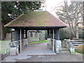
5
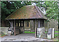
Maltby - lych gate of St Bartholomew's Church
For an alternative view, please see Image
Image: © Dave Bevis
Taken: 18 Aug 2014
0.10 miles
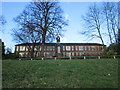
6
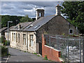
Maltby - former school on Church Lane
For an alternative view, please see Image
Image: © Dave Bevis
Taken: 18 Aug 2014
0.10 miles
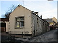
8
Church Lane, Maltby
View up the lane from the church gate.
Image: © Andrew Hill
Taken: 19 Sep 2012
0.11 miles
10
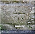
Ordnance Survey 1GL Bolt
This OS Bolt can be found on the west face of St Bartholomew's Church. It marks a point 85.146m above mean sea level.
Image: © Adrian Dust
Taken: 6 Jun 2016
0.11 miles