IMAGES TAKEN NEAR TO
Braithwell Road, ROTHERHAM, S66 8JU
Introduction
This page details the photographs taken nearby to Braithwell Road, S66 8JU by members of the Geograph project.
The Geograph project started in 2005 with the aim of publishing, organising and preserving representative images for every square kilometre of Great Britain, Ireland and the Isle of Man.

There are currently over 7.5m images from over14,400 individuals and you can help contribute to the project by visiting https://www.geograph.org.uk
Image Map
Images are licensed for reuse under creativecommons.org/licenses/by-sa/2.0
Notes
- Clicking on the map will re-center to the selected point.
- The higher the marker number, the further away the image location is from the centre of the postcode.
Image Listing (38 Images Found)
Images are licensed for reuse under creativecommons.org/licenses/by-sa/2.0
Image
Details
Distance
4
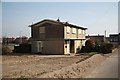
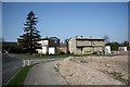
Last house standing
The last house on Chadwick Drive before demolition
Image: © Richard Croft
Taken: 20 Mar 2009
0.14 miles
5
Newland Avenue
A few remaining houses on Newland Avenue facing the prospect of demolition
Image: © Richard Croft
Taken: 20 Mar 2009
0.17 miles
6
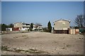
Empty houses
Council house clearance in Maltby .... some have already been demolished and cleared, these houses on Chadwick Drive and Newland Avenue face a similar fate
Image: © Richard Croft
Taken: 20 Mar 2009
0.17 miles
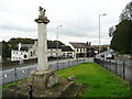
8

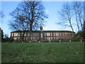
Memorial Cross and Garden in Maltby
Image: © Jonathan Clitheroe
Taken: 2 Sep 2017
0.20 miles
10
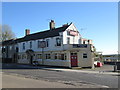
Maltby Cross
Unfortunately the top of the cross is damaged. It appears to have been a 'St Andrew's' cross in a circle. The road on the left was constructed sometime after 1929 to bypass the narrow road that passes the 'White Swan'. There is a well or trough in a niche at the foot of the retaining wall that supports the new road.
Image: © Humphrey Bolton
Taken: 24 Oct 2015
0.21 miles