IMAGES TAKEN NEAR TO
Manor Close, ROTHERHAM, S66 8JQ
Introduction
This page details the photographs taken nearby to Manor Close, S66 8JQ by members of the Geograph project.
The Geograph project started in 2005 with the aim of publishing, organising and preserving representative images for every square kilometre of Great Britain, Ireland and the Isle of Man.

There are currently over 7.5m images from over14,400 individuals and you can help contribute to the project by visiting https://www.geograph.org.uk
Image Map (Loading...)


Getting Data...Please wait
Leaflet Map data © OpenStreetMap
Images are licensed for reuse under creativecommons.org/licenses/by-sa/2.0
Notes
- Clicking on the map will re-center to the selected point.
- The higher the marker number, the further away the image location is from the centre of the postcode.
Image Listing (38 Images Found)
Images are licensed for reuse under creativecommons.org/licenses/by-sa/2.0
Image
Details
Distance
5
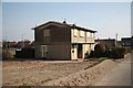
Last house standing
The last house on Chadwick Drive before demolition
Image: © Richard Croft
Taken: 20 Mar 2009
0.16 miles
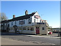
6

Memorial Cross and Garden in Maltby
Image: © Jonathan Clitheroe
Taken: 2 Sep 2017
0.18 miles
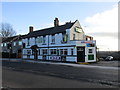
10
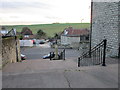
Steps and Crossley Memorial
For a description of the Crossley Memorial see Image
The red-roofed building is 27 Blyth Road a listed early eighteenth century house http://www.britishlistedbuildings.co.uk/en-335913-27-blyth-road-maltby-#.VpGEtuKWMnA
Image: © Jonathan Thacker
Taken: 8 Jan 2016
0.19 miles