IMAGES TAKEN NEAR TO
Meadow Spring View, ROTHERHAM, S66 8FS
Introduction
This page details the photographs taken nearby to Meadow Spring View, S66 8FS by members of the Geograph project.
The Geograph project started in 2005 with the aim of publishing, organising and preserving representative images for every square kilometre of Great Britain, Ireland and the Isle of Man.

There are currently over 7.5m images from over14,400 individuals and you can help contribute to the project by visiting https://www.geograph.org.uk
Image Map
Images are licensed for reuse under creativecommons.org/licenses/by-sa/2.0
Notes
- Clicking on the map will re-center to the selected point.
- The higher the marker number, the further away the image location is from the centre of the postcode.
Image Listing (60 Images Found)
Images are licensed for reuse under creativecommons.org/licenses/by-sa/2.0
Image
Details
Distance
1
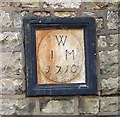
Datestone
Datestone of JM 1710 on the grade II listed 27 Blyth Road http://www.geograph.org.uk/photo/1602220
Image: © Richard Croft
Taken: 1 Dec 2009
0.02 miles
2
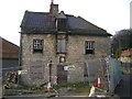
27 Blyth Road
Grade II listed building with datestone of 'JM 1710' on Blyth Road in Maltby .... in need of some repairs
Image: © Richard Croft
Taken: 1 Dec 2009
0.03 miles
3
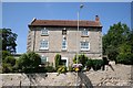
Maltby
Handsome 18th century house in the heart of old Maltby facing the cross
Image: © Richard Croft
Taken: 24 Jul 2006
0.04 miles
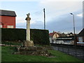
4
Memorial to William Crossley
The inscription reads ...“In memory of William Henry Crossley who was fatally injured near this spot on St.Paul’s Day 1900” Erected by his widow and children.
Image: © Richard Croft
Taken: 24 Jul 2006
0.04 miles
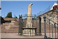
5
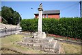
Maltby Cross
Medieval cross at the junction of High Street and Blyth Road
Image: © Richard Croft
Taken: 24 Jul 2006
0.04 miles
6
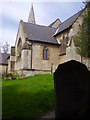
Maltby church.
Footpath runs alongside church.
Image: © steven ruffles
Taken: 27 Apr 2010
0.05 miles
7
Market Cross, Maltby
Of indeterminate medieval date.
Image: © Jonathan Thacker
Taken: 8 Jan 2016
0.05 miles
8
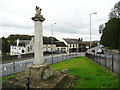
Maltby Cross
Unfortunately the top of the cross is damaged. It appears to have been a 'St Andrew's' cross in a circle. The road on the left was constructed sometime after 1929 to bypass the narrow road that passes the 'White Swan'. There is a well or trough in a niche at the foot of the retaining wall that supports the new road.
Image: © Humphrey Bolton
Taken: 24 Oct 2015
0.06 miles
9
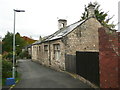
Former school, Church Lane, Maltby
The building has a datestone inscribed '1884'.
Image: © Humphrey Bolton
Taken: 24 Oct 2015
0.06 miles
10
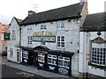
The White Swan Maltby
Predates Maltby's coalmining era.
Image: © Jonathan Thacker
Taken: 8 Jan 2016
0.06 miles