IMAGES TAKEN NEAR TO
Dunstan Road, ROTHERHAM, S66 8BS
Introduction
This page details the photographs taken nearby to Dunstan Road, S66 8BS by members of the Geograph project.
The Geograph project started in 2005 with the aim of publishing, organising and preserving representative images for every square kilometre of Great Britain, Ireland and the Isle of Man.

There are currently over 7.5m images from over14,400 individuals and you can help contribute to the project by visiting https://www.geograph.org.uk
Image Map (Loading...)


Getting Data...Please wait
Leaflet Map data © OpenStreetMap
Images are licensed for reuse under creativecommons.org/licenses/by-sa/2.0
Notes
- Clicking on the map will re-center to the selected point.
- The higher the marker number, the further away the image location is from the centre of the postcode.
Image Listing (8 Images Found)
Images are licensed for reuse under creativecommons.org/licenses/by-sa/2.0
Image
Details
Distance
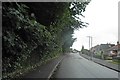
2
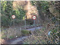
Hooton Lane meets Carr Lane
The 30 mph speed limit signs are on Carr Lane.
Image: © Jonathan Thacker
Taken: 8 Jan 2016
0.15 miles
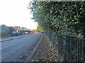
3
Hooton Lane
Approaching Carr Lane.
Not open to vehicular traffic.
Image: © Jonathan Thacker
Taken: 8 Jan 2016
0.17 miles
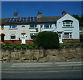
6
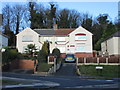
Houses on Rolleston Avenue
Typical of much of Maltby.
Image: © Jonathan Thacker
Taken: 8 Jan 2016
0.18 miles

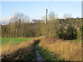
8
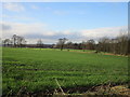
View towards Carr Lane from Hooton Lane
Carr Lane is marked by the row of trees across the centre of the picture.
Image: © Jonathan Thacker
Taken: 8 Jan 2016
0.25 miles