IMAGES TAKEN NEAR TO
Austwood Lane, ROTHERHAM, S66 7RJ
Introduction
This page details the photographs taken nearby to Austwood Lane, S66 7RJ by members of the Geograph project.
The Geograph project started in 2005 with the aim of publishing, organising and preserving representative images for every square kilometre of Great Britain, Ireland and the Isle of Man.

There are currently over 7.5m images from over14,400 individuals and you can help contribute to the project by visiting https://www.geograph.org.uk
Image Map
Images are licensed for reuse under creativecommons.org/licenses/by-sa/2.0
Notes
- Clicking on the map will re-center to the selected point.
- The higher the marker number, the further away the image location is from the centre of the postcode.
Image Listing (9 Images Found)
Images are licensed for reuse under creativecommons.org/licenses/by-sa/2.0
Image
Details
Distance
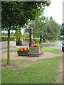
3

Village Cross
The inscription reads "This cross was erected to commemorate The freeing from bondage of KING RICHARD I circa 1191 Restored in the Coronation year of Her Majesty QUEEN ELIZABETH II 1953"
Has anyone fixed the wonky sign in the background?
Image: © Chris Field
Taken: 29 Dec 2007
0.21 miles
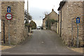
4
Village Street
The Red Lion pub with the ancient cross in the foreground. In the background is the Butchers Arms.
Image: © Chris Field
Taken: 29 Dec 2007
0.22 miles
6
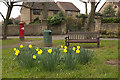
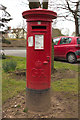
Daffodils, Braithwell
A closer view of the Postbox can be seen here: Image
Image: © Mark Anderson
Taken: 23 Mar 2016
0.24 miles
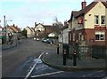
8
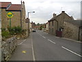
Village scene.
Braithwell high street.
Image: © steven ruffles
Taken: 24 Apr 2012
0.24 miles
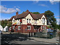
9
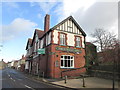
The Butchers Arms, Braithwell
Oh dear. The Red Lion has gone and now this pub has the For Sale sign out.
Image: © John Slater
Taken: 12 Nov 2013
0.24 miles