IMAGES TAKEN NEAR TO
Ruddle Mill Lane, ROTHERHAM, S66 7RH
Introduction
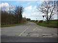
This page details the photographs taken nearby to Ruddle Mill Lane, S66 7RH by members of the Geograph project.
The Geograph project started in 2005 with the aim of publishing, organising and preserving representative images for every square kilometre of Great Britain, Ireland and the Isle of Man.

There are currently over 7.5m images from over14,400 individuals and you can help contribute to the project by visiting https://www.geograph.org.uk
Image Map
Images are licensed for reuse under creativecommons.org/licenses/by-sa/2.0
Notes
- Clicking on the map will re-center to the selected point.
- The higher the marker number, the further away the image location is from the centre of the postcode.
Image Listing (11 Images Found)
Images are licensed for reuse under creativecommons.org/licenses/by-sa/2.0
Image
Details
Distance
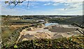
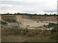
4
Marshall's dolomitic limestone quarry Stainton
From the bridge linking the two sides of the quarry on Cockhill Lane.
Image: © Steve Fareham
Taken: 19 Dec 2007
0.13 miles
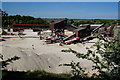
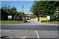
7
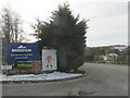
Entrance to Holme hall quarry.
In the village of Stainton.
Image: © steven ruffles
Taken: 13 Feb 2021
0.17 miles