IMAGES TAKEN NEAR TO
Tickhill Road, ROTHERHAM, S66 7QN
Introduction
This page details the photographs taken nearby to Tickhill Road, S66 7QN by members of the Geograph project.
The Geograph project started in 2005 with the aim of publishing, organising and preserving representative images for every square kilometre of Great Britain, Ireland and the Isle of Man.

There are currently over 7.5m images from over14,400 individuals and you can help contribute to the project by visiting https://www.geograph.org.uk
Image Map
Images are licensed for reuse under creativecommons.org/licenses/by-sa/2.0
Notes
- Clicking on the map will re-center to the selected point.
- The higher the marker number, the further away the image location is from the centre of the postcode.
Image Listing (7 Images Found)
Images are licensed for reuse under creativecommons.org/licenses/by-sa/2.0
Image
Details
Distance
1
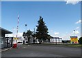
Entrance to Aven Industrial Estate, Maltby
Image: © Neil Theasby
Taken: 9 Aug 2014
0.04 miles
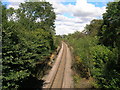
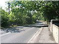
3
Maltby Station
On the former South Yorkshire Joint Railway, a line principally geared to the transport of coal from the local coalfield, it only enjoyed passenger services between 1910 and 1929. There would at one time have been two tracks through the station.
Image: © Alan Murray-Rust
Taken: 10 Feb 2010
0.18 miles
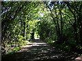
4
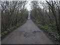
Track to Sandbeck
This track leads to Sandbeck Lodge.
Image: © Michael Patterson
Taken: 22 Dec 2006
0.21 miles
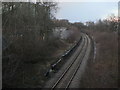
6
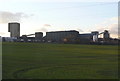
Maltby Colliery
View from the junction of Tickhill Road and Scotch Spring Lane of one of the last remaining deep pits in the UK.
Image: © Alan Murray-Rust
Taken: 10 Feb 2010
0.24 miles