IMAGES TAKEN NEAR TO
Lime Grove, ROTHERHAM, S66 7NT
Introduction
This page details the photographs taken nearby to Lime Grove, S66 7NT by members of the Geograph project.
The Geograph project started in 2005 with the aim of publishing, organising and preserving representative images for every square kilometre of Great Britain, Ireland and the Isle of Man.

There are currently over 7.5m images from over14,400 individuals and you can help contribute to the project by visiting https://www.geograph.org.uk
Image Map
Images are licensed for reuse under creativecommons.org/licenses/by-sa/2.0
Notes
- Clicking on the map will re-center to the selected point.
- The higher the marker number, the further away the image location is from the centre of the postcode.
Image Listing (34 Images Found)
Images are licensed for reuse under creativecommons.org/licenses/by-sa/2.0
Image
Details
Distance
2
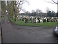
Maltby Cemetery
Maltby Cemetery a few days before Christmas is well attended and flowers are fresh.
Image: © Michael Patterson
Taken: 22 Dec 2006
0.12 miles
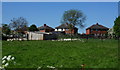
3
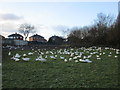
Christmas survivors
An allotment full of geese.
Image: © Jonathan Thacker
Taken: 8 Jan 2016
0.13 miles
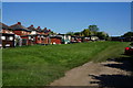
5
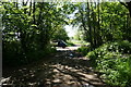
Lane towards the allotments east of Maltby
Image: © John Slater
Taken: 12 Nov 2013
0.16 miles
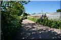
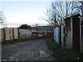
6
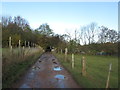
Track between the allotments
Two former railway vans used as sheds.
Image: © Jonathan Thacker
Taken: 8 Jan 2016
0.17 miles
8
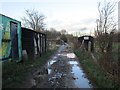
Corrugated iron fences
Protecting allotments.
Image: © Jonathan Thacker
Taken: 8 Jan 2016
0.17 miles