IMAGES TAKEN NEAR TO
Woodside Close, ROTHERHAM, S66 7NJ
Introduction
This page details the photographs taken nearby to Woodside Close, S66 7NJ by members of the Geograph project.
The Geograph project started in 2005 with the aim of publishing, organising and preserving representative images for every square kilometre of Great Britain, Ireland and the Isle of Man.

There are currently over 7.5m images from over14,400 individuals and you can help contribute to the project by visiting https://www.geograph.org.uk
Image Map
Images are licensed for reuse under creativecommons.org/licenses/by-sa/2.0
Notes
- Clicking on the map will re-center to the selected point.
- The higher the marker number, the further away the image location is from the centre of the postcode.
Image Listing (35 Images Found)
Images are licensed for reuse under creativecommons.org/licenses/by-sa/2.0
Image
Details
Distance
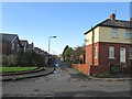
1
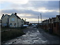
Gelncairne Close
Looking towards Tickhill Road.
Image: © Jonathan Thacker
Taken: 8 Jan 2016
0.03 miles
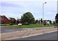
3
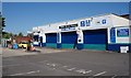
Maltby Service Station
On Tickhill Road, Maltby.
Image: © Ian S
Taken: 17 May 2014
0.06 miles
4
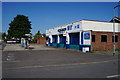
Maltby Service Station
On Tickhill Road, Maltby.
Image: © Ian S
Taken: 17 May 2014
0.06 miles
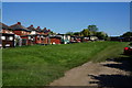
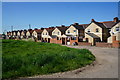
7
Green Space and Road Junction in Maltby
Image: © Jonathan Clitheroe
Taken: 7 Jun 2017
0.10 miles
8
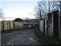
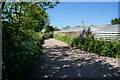
Corrugated iron fences
Protecting allotments.
Image: © Jonathan Thacker
Taken: 8 Jan 2016
0.11 miles
10
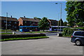
Bus terminus on Tickhill Road, Maltby
Taken from the beer garden of the Lumley Arms. One of two Sam Smith's public houses in Maltby.
Image: © Ian S
Taken: 17 May 2014
0.13 miles