IMAGES TAKEN NEAR TO
Carlyle Road, ROTHERHAM, S66 7LP
Introduction
This page details the photographs taken nearby to Carlyle Road, S66 7LP by members of the Geograph project.
The Geograph project started in 2005 with the aim of publishing, organising and preserving representative images for every square kilometre of Great Britain, Ireland and the Isle of Man.

There are currently over 7.5m images from over14,400 individuals and you can help contribute to the project by visiting https://www.geograph.org.uk
Image Map
Images are licensed for reuse under creativecommons.org/licenses/by-sa/2.0
Notes
- Clicking on the map will re-center to the selected point.
- The higher the marker number, the further away the image location is from the centre of the postcode.
Image Listing (59 Images Found)
Images are licensed for reuse under creativecommons.org/licenses/by-sa/2.0
Image
Details
Distance
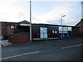
1
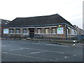
QDOS and TSL
This was clearly a public building at one time.
Image: © Jonathan Thacker
Taken: 8 Jan 2016
0.08 miles
2
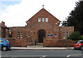
Maltby - St Mary's RC Church
On Morrell Street.
Image: © Dave Bevis
Taken: 18 Aug 2014
0.08 miles
3
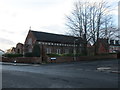
St. Mary Magdalene Roman Catholic church
Image: © Jonathan Thacker
Taken: 8 Jan 2016
0.08 miles
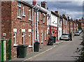
5
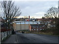
Carlyle Road
The rear of Tesco in the centre of the picture with the fire station tower prominent above.
Image: © Jonathan Thacker
Taken: 8 Jan 2016
0.12 miles
8
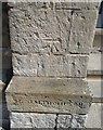
Ordnance Survey Cut Mark
This OS cut mark can be found on the Methodist Chapel on Blyth Road. It marks a point 96.728m above mean sea level.
Image: © Adrian Dust
Taken: 6 Jun 2016
0.13 miles
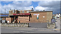
10
Maltby - rear of former Co-op
The front of the Co-op is on High Street (see Image), with the rear on Millindale.
Image: © Dave Bevis
Taken: 18 Aug 2014
0.15 miles