IMAGES TAKEN NEAR TO
Hardie Close, ROTHERHAM, S66 7JS
Introduction
This page details the photographs taken nearby to Hardie Close, S66 7JS by members of the Geograph project.
The Geograph project started in 2005 with the aim of publishing, organising and preserving representative images for every square kilometre of Great Britain, Ireland and the Isle of Man.

There are currently over 7.5m images from over14,400 individuals and you can help contribute to the project by visiting https://www.geograph.org.uk
Image Map
Images are licensed for reuse under creativecommons.org/licenses/by-sa/2.0
Notes
- Clicking on the map will re-center to the selected point.
- The higher the marker number, the further away the image location is from the centre of the postcode.
Image Listing (4 Images Found)
Images are licensed for reuse under creativecommons.org/licenses/by-sa/2.0
Image
Details
Distance
1
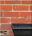
Ordnance Survey Cut Mark
This OS cut mark can be found on No168 Muglet Lane. It marks a point 108.853m above mean sea level.
Image: © Adrian Dust
Taken: 6 Jun 2016
0.16 miles
3
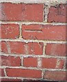
Ordnance Survey Cut Mark
This OS cut mark can be found on the west face of No 11 Victoria Street. It marks a point 105.927m above mean sea level.
Image: © Adrian Dust
Taken: 6 Jun 2016
0.23 miles
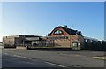
4
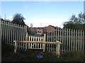
Well defended railway crossing at Maltby
Image: © John Slater
Taken: 12 Nov 2013
0.25 miles