IMAGES TAKEN NEAR TO
Hayhurst Crescent, ROTHERHAM, S66 7HN
Introduction
This page details the photographs taken nearby to Hayhurst Crescent, S66 7HN by members of the Geograph project.
The Geograph project started in 2005 with the aim of publishing, organising and preserving representative images for every square kilometre of Great Britain, Ireland and the Isle of Man.

There are currently over 7.5m images from over14,400 individuals and you can help contribute to the project by visiting https://www.geograph.org.uk
Image Map
Images are licensed for reuse under creativecommons.org/licenses/by-sa/2.0
Notes
- Clicking on the map will re-center to the selected point.
- The higher the marker number, the further away the image location is from the centre of the postcode.
Image Listing (24 Images Found)
Images are licensed for reuse under creativecommons.org/licenses/by-sa/2.0
Image
Details
Distance
1
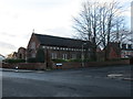
St. Mary Magdalene Roman Catholic church
Image: © Jonathan Thacker
Taken: 8 Jan 2016
0.07 miles
2
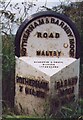
Old Milestone, on the A634, Blyth Road
30m S of junction with Morrell Street opposite. Located on the West side of road, on verge. Metal plate attached to stone post, Brayshaw & Booth casting design, 19th century.
Inscription reads: ROTHERHAM / 7 MILES // BARNBY / MOOR / 10 MILES // ROTHERHAM & BARNBY MOOR / ROAD / MALTBY // BRAYSHAW & BOOTH / MAKERS / LIVERSEDGE
Grade II listed by Historic England. see https://historicengland.org.uk/listing/the-list/list-entry/1192734
Milestone Society National ID: YS_RMBM07
Image: © Christine Minto
Taken: 3 Jan 2006
0.07 miles
3
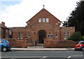
Maltby - St Mary's RC Church
On Morrell Street.
Image: © Dave Bevis
Taken: 18 Aug 2014
0.07 miles
4
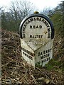
Old milestone, A634, Blyth Road, Maltby
One of the 615 milestones erected for the West Riding County Council in 1893/94. Over half are still in situ over all the old West Riding. In summer this stone is completely hidden amongst the bracken so has escaped the notice of the person who painted the next two stones eastwards. The post 3 miles away is missing and the road enters Nottinghamshire after another ½ mile.
Image: © Chris Minto
Taken: 22 Feb 2021
0.07 miles
5
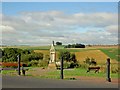
The Great War memorial on Blyth Road Maltby
Image: © Steve Fareham
Taken: 4 Aug 2008
0.08 miles
6
Maltby - war memorial on Blyth Road
For an alternative view, please see Image
Image: © Dave Bevis
Taken: 18 Aug 2014
0.08 miles
7
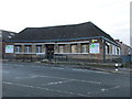
QDOS and TSL
This was clearly a public building at one time.
Image: © Jonathan Thacker
Taken: 8 Jan 2016
0.09 miles
8
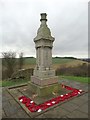
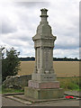
War memorial, Maltby
Above Maltby Crags, overlooking the valley of Maltby Beck and remembering local men who paid the ultimate sacrifice in two world wars.
Image: © Neil Theasby
Taken: 18 Dec 2015
0.09 miles
9
Ordnance Survey Rivet
This OS rivet can be found on the rock opposite the junction of Blyth Road and Queens Avenue. It marks a point 111.749m above mean sea level.
Image: © Adrian Dust
Taken: 6 Jun 2016
0.10 miles
10
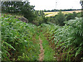
Maltby - footpath from war memorial to Wood Lee
Image: © Dave Bevis
Taken: 18 Aug 2014
0.12 miles