IMAGES TAKEN NEAR TO
Nookery Close, ROTHERHAM, S66 7BJ
Introduction
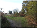
This page details the photographs taken nearby to Nookery Close, S66 7BJ by members of the Geograph project.
The Geograph project started in 2005 with the aim of publishing, organising and preserving representative images for every square kilometre of Great Britain, Ireland and the Isle of Man.

There are currently over 7.5m images from over14,400 individuals and you can help contribute to the project by visiting https://www.geograph.org.uk
Image Map
Images are licensed for reuse under creativecommons.org/licenses/by-sa/2.0
Notes
- Clicking on the map will re-center to the selected point.
- The higher the marker number, the further away the image location is from the centre of the postcode.
Image Listing (11 Images Found)
Images are licensed for reuse under creativecommons.org/licenses/by-sa/2.0
Image
Details
Distance
4
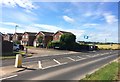
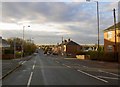
Grange Lane in Maltby
Pictured here at its junction with Autumn Drive. The edge of housing development here corresponds exactly with the northern extent of the square with the open countryside located to the north in SK5393.
Image: © Jonathan Clitheroe
Taken: 1 Jul 2017
0.15 miles