IMAGES TAKEN NEAR TO
Braithwell, ROTHERHAM, S66 7AB
Introduction
This page details the photographs taken nearby to S66 7AB by members of the Geograph project.
The Geograph project started in 2005 with the aim of publishing, organising and preserving representative images for every square kilometre of Great Britain, Ireland and the Isle of Man.

There are currently over 7.5m images from over14,400 individuals and you can help contribute to the project by visiting https://www.geograph.org.uk
Image Map
Images are licensed for reuse under creativecommons.org/licenses/by-sa/2.0
Notes
- Clicking on the map will re-center to the selected point.
- The higher the marker number, the further away the image location is from the centre of the postcode.
Image Listing (6 Images Found)
Images are licensed for reuse under creativecommons.org/licenses/by-sa/2.0
Image
Details
Distance
2
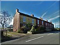
The Hawthornes
Cottages on Fish Pond Lane near Braithwell
Image: © Neil Theasby
Taken: 1 Mar 2022
0.02 miles
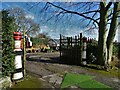
4

Chimney pot gates
Gates to garden centre (the other garden centre) in Braithwell.
Image: © Steve Fareham
Taken: 25 Oct 2007
0.13 miles
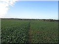
6
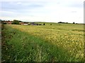
Lambcote Grange and Surrounding Crop Fields
Pictured from Grange Lane.
Image: © Jonathan Clitheroe
Taken: 7 Jun 2017
0.23 miles