IMAGES TAKEN NEAR TO
Bramley Grange Way, ROTHERHAM, S66 2UW
Introduction
This page details the photographs taken nearby to Bramley Grange Way, S66 2UW by members of the Geograph project.
The Geograph project started in 2005 with the aim of publishing, organising and preserving representative images for every square kilometre of Great Britain, Ireland and the Isle of Man.

There are currently over 7.5m images from over14,400 individuals and you can help contribute to the project by visiting https://www.geograph.org.uk
Image Map
Images are licensed for reuse under creativecommons.org/licenses/by-sa/2.0
Notes
- Clicking on the map will re-center to the selected point.
- The higher the marker number, the further away the image location is from the centre of the postcode.
Image Listing (6 Images Found)
Images are licensed for reuse under creativecommons.org/licenses/by-sa/2.0
Image
Details
Distance
5
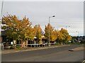
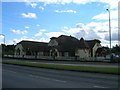
Autumn colour at Macdonald's Restaurant
In a small commercial development adjacent to Junction 1 on the M18.
Image: © Graham Hogg
Taken: 25 Oct 2021
0.24 miles
6
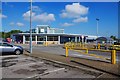
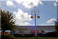
Morrisons, Bawtry Road, Bramley, Rotherham
Local branch of the national supermarket chain.
Image
Image: © P L Chadwick
Taken: 12 May 2019
0.25 miles