IMAGES TAKEN NEAR TO
Warde Aldam Crescent, ROTHERHAM, S66 2HN
Introduction
This page details the photographs taken nearby to Warde Aldam Crescent, S66 2HN by members of the Geograph project.
The Geograph project started in 2005 with the aim of publishing, organising and preserving representative images for every square kilometre of Great Britain, Ireland and the Isle of Man.

There are currently over 7.5m images from over14,400 individuals and you can help contribute to the project by visiting https://www.geograph.org.uk
Image Map
Images are licensed for reuse under creativecommons.org/licenses/by-sa/2.0
Notes
- Clicking on the map will re-center to the selected point.
- The higher the marker number, the further away the image location is from the centre of the postcode.
Image Listing (26 Images Found)
Images are licensed for reuse under creativecommons.org/licenses/by-sa/2.0
Image
Details
Distance
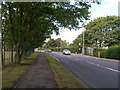
2
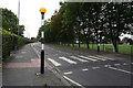
Zebra crossing on Northfield Lane, Wickersley
Image: © Ian S
Taken: 19 Sep 2018
0.12 miles
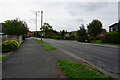
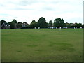
5
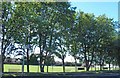
Wickersley Cricket ground behind the trees
Note the sign to Wickersley Park via Warren Road.
Image: © Steve Fareham
Taken: 4 Sep 2012
0.13 miles