IMAGES TAKEN NEAR TO
Slacks Lane, ROTHERHAM, S66 1TZ
Introduction
This page details the photographs taken nearby to Slacks Lane, S66 1TZ by members of the Geograph project.
The Geograph project started in 2005 with the aim of publishing, organising and preserving representative images for every square kilometre of Great Britain, Ireland and the Isle of Man.

There are currently over 7.5m images from over14,400 individuals and you can help contribute to the project by visiting https://www.geograph.org.uk
Image Map
Images are licensed for reuse under creativecommons.org/licenses/by-sa/2.0
Notes
- Clicking on the map will re-center to the selected point.
- The higher the marker number, the further away the image location is from the centre of the postcode.
Image Listing (9 Images Found)
Images are licensed for reuse under creativecommons.org/licenses/by-sa/2.0
Image
Details
Distance
1

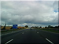
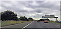
Bramley : M18 Motorway
Heading north on the M18 Motorway.
Image: © Lewis Clarke
Taken: 20 Sep 2020
0.08 miles
2
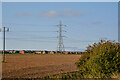
Bramley : Ploughed Field
A ploughed field with pylons heading through it near Bramley.
Image: © Lewis Clarke
Taken: 20 Sep 2020
0.08 miles
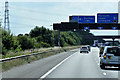
5
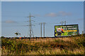
Bramley : Roadside
Looking towards the side of the road with a sign promoting a redn panda at Yorkshire Wildlife Park.
Image: © Lewis Clarke
Taken: 20 Sep 2020
0.14 miles
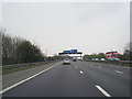
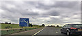
8
Southbound M18, approaching Interchange with M1
Image: © David Dixon
Taken: 8 Aug 2015
0.21 miles