IMAGES TAKEN NEAR TO
The Crofts, ROTHERHAM, S66 1NQ
Introduction
This page details the photographs taken nearby to The Crofts, S66 1NQ by members of the Geograph project.
The Geograph project started in 2005 with the aim of publishing, organising and preserving representative images for every square kilometre of Great Britain, Ireland and the Isle of Man.

There are currently over 7.5m images from over14,400 individuals and you can help contribute to the project by visiting https://www.geograph.org.uk
Image Map (Loading...)


Getting Data...Please wait
Leaflet Map data © OpenStreetMap
Images are licensed for reuse under creativecommons.org/licenses/by-sa/2.0
Notes
- Clicking on the map will re-center to the selected point.
- The higher the marker number, the further away the image location is from the centre of the postcode.
Image Listing (37 Images Found)
Images are licensed for reuse under creativecommons.org/licenses/by-sa/2.0
Image
Details
Distance
6
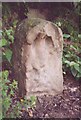
Old Milestone, B6060 Morthen Road
S of A631 (Bawtry Road). Located on the West side of road, in a verge side garden, near Oaklands opposite No 143. Carved stone post.
Milestone Society National ID: YS_WCTY
Image: © Christine Minto
Taken: 3 Jan 2006
0.10 miles
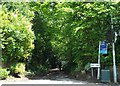
9
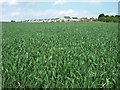
View across a cornfield towards Wickersley
Photograph taken whilst walking on Sandy Flat Lane.
Image: © Neil Theasby
Taken: 31 May 2013
0.11 miles
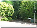
10
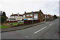
Springvale Close off Morthen Road, Wickersley
Image: © Ian S
Taken: 19 Sep 2018
0.12 miles