IMAGES TAKEN NEAR TO
Bawtry Road, ROTHERHAM, S66 1JJ
Introduction
This page details the photographs taken nearby to Bawtry Road, S66 1JJ by members of the Geograph project.
The Geograph project started in 2005 with the aim of publishing, organising and preserving representative images for every square kilometre of Great Britain, Ireland and the Isle of Man.

There are currently over 7.5m images from over14,400 individuals and you can help contribute to the project by visiting https://www.geograph.org.uk
Image Map
Images are licensed for reuse under creativecommons.org/licenses/by-sa/2.0
Notes
- Clicking on the map will re-center to the selected point.
- The higher the marker number, the further away the image location is from the centre of the postcode.
Image Listing (36 Images Found)
Images are licensed for reuse under creativecommons.org/licenses/by-sa/2.0
Image
Details
Distance
1
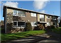
Sheltered housing for the elderly in Wickersley
Image: © Neil Theasby
Taken: 5 Nov 2014
0.05 miles
2
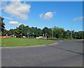
The roundabout on Bawtry Road Wickersley, Rotherham
Image: © Steve Fareham
Taken: 4 Sep 2012
0.09 miles

4
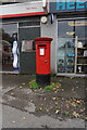
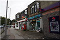
Post box at Wickersley Post Office on Bawtry Road
Image: © Ian S
Taken: 19 Sep 2018
0.12 miles
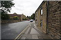
7

Goose Lane, Wickersley
By the junction with Lings Lane
Image: © Richard Croft
Taken: 24 Jul 2006
0.14 miles
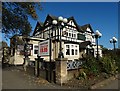
8

Masons Arms, Bawtry Road, Wickersley
http://www.geograph.org.uk/photo/5913097
Image: © Ian S
Taken: 19 Sep 2018
0.15 miles
9
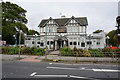
Masons Arms, Bawtry Road, Wickersley
http://www.geograph.org.uk/photo/5913100
Image: © Ian S
Taken: 19 Sep 2018
0.15 miles