IMAGES TAKEN NEAR TO
Lilac Farm Close, ROTHERHAM, S66 1FQ
Introduction
This page details the photographs taken nearby to Lilac Farm Close, S66 1FQ by members of the Geograph project.
The Geograph project started in 2005 with the aim of publishing, organising and preserving representative images for every square kilometre of Great Britain, Ireland and the Isle of Man.

There are currently over 7.5m images from over14,400 individuals and you can help contribute to the project by visiting https://www.geograph.org.uk
Image Map
Images are licensed for reuse under creativecommons.org/licenses/by-sa/2.0
Notes
- Clicking on the map will re-center to the selected point.
- The higher the marker number, the further away the image location is from the centre of the postcode.
Image Listing (39 Images Found)
Images are licensed for reuse under creativecommons.org/licenses/by-sa/2.0
Image
Details
Distance
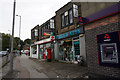
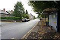
5
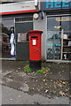
Post box at Wickersley Post Office on Bawtry Road
Image: © Ian S
Taken: 19 Sep 2018
0.07 miles
7
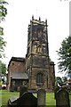
St. Alban's church, Wickersley
A 15th century Perpendicular tower with a nave of 1834 and chancel of 1886.
Image: © Richard Croft
Taken: 26 Jun 2006
0.07 miles
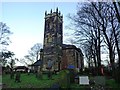
10
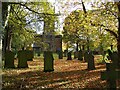
St Alban's churchyard
Grade II listed parish church dating from the 15th century.
Image: © Graham Hogg
Taken: 25 Oct 2021
0.08 miles