IMAGES TAKEN NEAR TO
Church Lane, ROTHERHAM, S66 1ES
Introduction
This page details the photographs taken nearby to Church Lane, S66 1ES by members of the Geograph project.
The Geograph project started in 2005 with the aim of publishing, organising and preserving representative images for every square kilometre of Great Britain, Ireland and the Isle of Man.

There are currently over 7.5m images from over14,400 individuals and you can help contribute to the project by visiting https://www.geograph.org.uk
Image Map
Images are licensed for reuse under creativecommons.org/licenses/by-sa/2.0
Notes
- Clicking on the map will re-center to the selected point.
- The higher the marker number, the further away the image location is from the centre of the postcode.
Image Listing (36 Images Found)
Images are licensed for reuse under creativecommons.org/licenses/by-sa/2.0
Image
Details
Distance
7
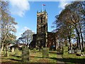
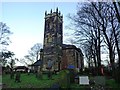
St Alban's Church in Wickersley
A church is believed to have stood in Wickersley since 1150. Frickley Hall (Ward Aldam) papers (1419) refer to the ‘Lamp of St Nicholas’ on the steeple directing travellers between Rotherham and Roche Abbey.
Image: © Neil Theasby
Taken: 5 Nov 2014
0.04 miles
8
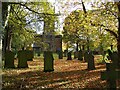
St Alban's churchyard
Grade II listed parish church dating from the 15th century.
Image: © Graham Hogg
Taken: 25 Oct 2021
0.04 miles