IMAGES TAKEN NEAR TO
Fairbarn Drive, SHEFFIELD, S6 5QL
Introduction
This page details the photographs taken nearby to Fairbarn Drive, S6 5QL by members of the Geograph project.
The Geograph project started in 2005 with the aim of publishing, organising and preserving representative images for every square kilometre of Great Britain, Ireland and the Isle of Man.

There are currently over 7.5m images from over14,400 individuals and you can help contribute to the project by visiting https://www.geograph.org.uk
Image Map
Images are licensed for reuse under creativecommons.org/licenses/by-sa/2.0
Notes
- Clicking on the map will re-center to the selected point.
- The higher the marker number, the further away the image location is from the centre of the postcode.
Image Listing (31 Images Found)
Images are licensed for reuse under creativecommons.org/licenses/by-sa/2.0
Image
Details
Distance
1
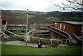
Liberty Hill, Sheffield
Liberty Hill with Rivelin Valley in the background and Sandygate on the top of the hill opposite. Photo taken just outside Hall Park Head community centre.
Liberty Hill was developed by Sheffield City Council in the 1960s and 1970s. The property is a mix of traditional houses, small two-storey flats and the "Swiss-Chalet" type buildings in the near foreground. Due to the slope of the ground both floors have ground level access.
Image: © J G Harston
Taken: Unknown
0.03 miles
3

Hall Park Head bus terminus
Not a turning circle as such, the terminus at Hall Park Head is simply a huge patch of tarmac that, due to the hilly topography of the area, proved impossible to get into a photo in its entirety. The housing on the right (behind the willow tree) is built on a hillside, while the ground drops sharply to the photographer's left.
Image: © Richard Vince
Taken: 24 Apr 2012
0.06 miles
4
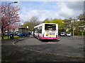
Bus loading at Hall Park Head
Passengers board a 12 to Sheffield city centre at Hall Park Head terminus. Some of the interestingly designed housing that slopes in sympathy with the hillside on which it is built is visible on the right.
Image: © Richard Vince
Taken: 24 Apr 2012
0.06 miles
5
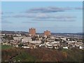
Oldfield Road, Stannington
Oldfield Road, Stannington looking towards the Deer Park tower-blocks.
Image: © Martin Speck
Taken: 8 Apr 2009
0.09 miles
6
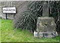
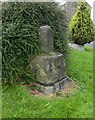
Stannington Stump Cross
Harrison's survey of 1637 describes it as a "stump cross of medieval origin". The date of erection has been estimated as 13th or 14th century. It stands at the junction of Oldfield Road and Stannington Road.
Image: © Neil Theasby
Taken: 20 Mar 2015
0.10 miles
7
Old Wayside Cross by Oldfield Road, Bradfield parish
Stannington Cross, old shaft and base by the UC road, in parish of Bradfield (Sheffield District), Oldfield Road; at junction with Stannington Road, by The Sportsman PH, on verge with back to boundary wall at junction.
Grade II listed.
List Entry Number: 1132854 https://historicengland.org.uk/listing/the-list/list-entry/1132854
Surveyed
Milestone Society National ID: YSSH_BRA02
Image: © Alan Rosevear
Taken: 21 Sep 2012
0.10 miles
9
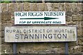
Stannington Signs - 1
It's a long time since the Stannington Area of Sheffield was included within the Rural District of Wortley but this sign still proudly announces it. Shame about the advertising sign above which detracts from the historic one ... doesn't anybody in planning care?
Image: © Terry Robinson
Taken: 14 Sep 2008
0.11 miles
10
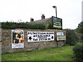
Stannington Signs - 2
From ABBA to WRDC ... is planning permission needed for these signs? Image
Image: © Terry Robinson
Taken: 14 Sep 2008
0.11 miles