IMAGES TAKEN NEAR TO
Roscoe Mount, SHEFFIELD, S6 5PG
Introduction
This page details the photographs taken nearby to Roscoe Mount, S6 5PG by members of the Geograph project.
The Geograph project started in 2005 with the aim of publishing, organising and preserving representative images for every square kilometre of Great Britain, Ireland and the Isle of Man.

There are currently over 7.5m images from over14,400 individuals and you can help contribute to the project by visiting https://www.geograph.org.uk
Image Map (Loading...)


Getting Data...Please wait
Leaflet Map data © OpenStreetMap
Images are licensed for reuse under creativecommons.org/licenses/by-sa/2.0
Notes
- Clicking on the map will re-center to the selected point.
- The higher the marker number, the further away the image location is from the centre of the postcode.
Image Listing (44 Images Found)
Images are licensed for reuse under creativecommons.org/licenses/by-sa/2.0
Image
Details
Distance

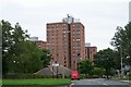
2
Stannington Road, Sheffield
Looking west on the B6076.
Image: © JThomas
Taken: 30 Jun 2018
0.09 miles
4
Roscoe Bank, Stannington, Sheffield
The former Bell Hagg Inn, that closed in 2005, can be seen on the northern side of the A57 (the main Sheffield -Manchester Road), near Crosspool. It finally closed in 2005 and has now been converted into a seven-bedroom family home. It is believed that the original building was erected in 1832 as a five-storey house for a certain Dr Hodgeson who had built it as a folly to antagonise the Vicar of Stannington after the incumbent turned down the offer of a generous donation from him because Hodgeson had made much of his fortune from gambling. Before becoming a pub the building was used as a tea room by workers associated with a former quarry opposite it (that is now occupied by the Valleyside Garden Centre), and also by travellers between these two northern cities.
Image: © David Hallam-Jones
Taken: 18 Feb 2018
0.13 miles
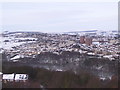
6
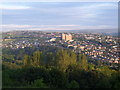
Stannington from Bole Hill
The view over the Rivelin Valley in 2011. Submitted to the BBC Domesday Reloaded project. Image For another BBC Domesday Reloaded project image see Image
Image: © Martin Speck
Taken: 7 Jun 2011
0.13 miles
7

Fairbarn Drive
Local authority built housing on Fairbarn Drive.
Image: © Martin Speck
Taken: 8 Apr 2009
0.14 miles
8
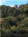
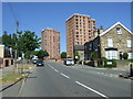
View to Deer Park Flats, Stannington from Rivelin Valley Road
Image: © Neil Theasby
Taken: 6 Oct 2010
0.14 miles
9

Site of water mill in the Rivelin Valley
The River Rivelin is only 3 and a half miles long but once powered twenty mills, of which this was one. The pond which fed this mill has been drained but many others still survive. The oldest recorded mill was established in 1581 and the last working mill was still grinding scythes in 1939.
Image: © Graham Hogg
Taken: 4 Apr 2011
0.14 miles
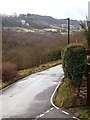
10
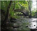
Roscoe Bridge
The bridge dates from the 18th century and gave access to the Roscoe Wheel, one of 20 water wheels in a 3-mile stretch of the river that were active in the 19th century
Image: © Graham Hogg
Taken: 10 Sep 2020
0.14 miles