IMAGES TAKEN NEAR TO
Stannington Rise, SHEFFIELD, S6 5HH
Introduction
This page details the photographs taken nearby to Stannington Rise, S6 5HH by members of the Geograph project.
The Geograph project started in 2005 with the aim of publishing, organising and preserving representative images for every square kilometre of Great Britain, Ireland and the Isle of Man.

There are currently over 7.5m images from over14,400 individuals and you can help contribute to the project by visiting https://www.geograph.org.uk
Image Map
Images are licensed for reuse under creativecommons.org/licenses/by-sa/2.0
Notes
- Clicking on the map will re-center to the selected point.
- The higher the marker number, the further away the image location is from the centre of the postcode.
Image Listing (77 Images Found)
Images are licensed for reuse under creativecommons.org/licenses/by-sa/2.0
Image
Details
Distance
1

Former Gateway to Woodville House, Wood Lane, Malin Bridge, Sheffield
Woodville House has long gone, with industrial units on the site ... but these gates still (just) bear the name. Image Image
Image: © Terry Robinson
Taken: 29 Oct 2008
0.05 miles
2

Critter Sitter by The Anvil, Wood Lane, Stannington, Sheffield
Image: © Terry Robinson
Taken: 29 Oct 2008
0.05 miles
3
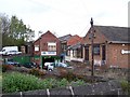
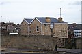
Industrial Units, Wood Lane, Malin Bridge, Sheffield - 1
These units are on the site of the former Woodville House ... with just some gates left to show it existed. Image Image
Image: © Terry Robinson
Taken: 29 Oct 2008
0.06 miles
4
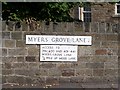
Street Sign, Myers Grove Lane, Malin Bridge, Sheffield
Image: © Terry Robinson
Taken: 25 Sep 2008
0.06 miles
5
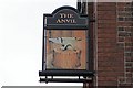
Pub Sign, The Anvil Pub, Stannington Road, Sheffield
Image: © Terry Robinson
Taken: 29 Oct 2008
0.06 miles
6

The Anvil Pub, Stannington Road, Sheffield
A pub, with this name, on the corner of Wood lane and stannington Road, is shown on the 1905 OS map of this area. It takes its name from the nearby Mousehole Forge, which was famous, worldwide, for the quality and range of anvils it produced. Image Image
Image: © Terry Robinson
Taken: 29 Oct 2008
0.06 miles
7
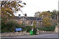
Wood Lane House, Farm Countryside Centre, Wood Lane, Malin Bridge, Sheffield
This is Wood Lane House Farm ... not to be confused with Wood Lane Farm, which is about 2 miles further up Wood Lane. Both Farms are still in use, this one has been converted into a Countryside Centre, serving the community in many ways ... http://www.woodlanecc.org.uk/index.htm ... Image Image
Image: © Terry Robinson
Taken: 29 Oct 2008
0.07 miles
8
Industrial Units, Wood Lane, Malin Bridge, Sheffield - 2
On the left, in the far distance, Malin Bridge School can be seen ... identified by its Domed Tower. Image Image
Image: © Terry Robinson
Taken: 29 Oct 2008
0.07 miles
9
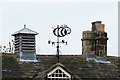
Weather Vane, Wood Lane House, Farm Countryside Centre, Wood Lane, Malin Bridge, Sheffield
Image: © Terry Robinson
Taken: 29 Oct 2008
0.07 miles
10

Chimney Details, Wood Lane House, Farm Countryside Centre, Wood Lane, Malin Bridge, Sheffield
Image: © Terry Robinson
Taken: 29 Oct 2008
0.08 miles