IMAGES TAKEN NEAR TO
Ivanhoe Road, SHEFFIELD, S6 5GB
Introduction
This page details the photographs taken nearby to Ivanhoe Road, S6 5GB by members of the Geograph project.
The Geograph project started in 2005 with the aim of publishing, organising and preserving representative images for every square kilometre of Great Britain, Ireland and the Isle of Man.

There are currently over 7.5m images from over14,400 individuals and you can help contribute to the project by visiting https://www.geograph.org.uk
Image Map
Images are licensed for reuse under creativecommons.org/licenses/by-sa/2.0
Notes
- Clicking on the map will re-center to the selected point.
- The higher the marker number, the further away the image location is from the centre of the postcode.
Image Listing (57 Images Found)
Images are licensed for reuse under creativecommons.org/licenses/by-sa/2.0
Image
Details
Distance
1
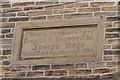
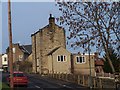
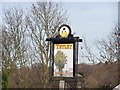
Almshouses Sign, Ivanhoe Road (formerly Ivy Road), Stannington, Sheffield
To view the Almshouses ... see ...
Image
Image: © Terry Robinson
Taken: 14 Jan 2009
0.03 miles
2
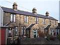
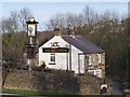
Almshouses, Ivanhoe Road (formerly Ivy Road), Stannington, Sheffield
Dates and details are shown in this link ... Image
Image: © Terry Robinson
Taken: 14 Jan 2009
0.03 miles
3
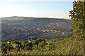
View to Stannington, from Bolehill Recreation Ground, Northfield Avenue, Crookes, Sheffield
Image: © Terry Robinson
Taken: 16 Aug 2013
0.06 miles
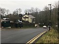
4
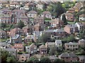
Rivelin Park Road, Stannington
The road can be seen running diagonally across the frame. The mixed row of houses at the bottom of the picture front Low Road.
Image: © Dave Hitchborne
Taken: 26 Aug 2008
0.09 miles
5
Rivelin Park Road, Lower Rivelin, Sheffield
An interesting mix of buildings near to The Holly Bush.
Image: © Terry Robinson
Taken: 14 Jan 2009
0.11 miles
6
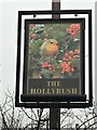
The sign of The Holly Bush
View of the pub here Image
Image: © David Lally
Taken: 22 Jan 2017
0.13 miles
8
"The Holly Bush", Rivelin Valley, Sheffield 10
Image: © Neil Theasby
Taken: 23 Aug 2011
0.13 miles
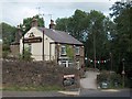
9
The Holly Bush, Hollins Lane, Lower Rivelin, Sheffield
This public house is shown in the 1905 OS Map ... and is still thriving. I remember going there many years ago when they 'hired out' a large barbecue area ... not sure if it's still there now. Hollins Lane, of course, means lane to the area with Holly Bushes in it. Nearby are Hollins Bridge, Hollins Farm and the remains of the former Hollins Bridge Mill ... must have been lots of Holly around! Image
Image: © Terry Robinson
Taken: 14 Jan 2009
0.14 miles
10
Pub Sign, The Holly Bush, Hollins Lane, Lower Rivelin, Sheffield
Image: © Terry Robinson
Taken: 14 Jan 2009
0.14 miles