IMAGES TAKEN NEAR TO
Low Road, SHEFFIELD, S6 5FY
Introduction
This page details the photographs taken nearby to Low Road, S6 5FY by members of the Geograph project.
The Geograph project started in 2005 with the aim of publishing, organising and preserving representative images for every square kilometre of Great Britain, Ireland and the Isle of Man.

There are currently over 7.5m images from over14,400 individuals and you can help contribute to the project by visiting https://www.geograph.org.uk
Image Map
Images are licensed for reuse under creativecommons.org/licenses/by-sa/2.0
Notes
- Clicking on the map will re-center to the selected point.
- The higher the marker number, the further away the image location is from the centre of the postcode.
Image Listing (45 Images Found)
Images are licensed for reuse under creativecommons.org/licenses/by-sa/2.0
Image
Details
Distance
1
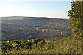
View to Stannington, from Bolehill Recreation Ground, Northfield Avenue, Crookes, Sheffield
Image: © Terry Robinson
Taken: 16 Aug 2013
0.04 miles
2
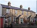
Almshouses, Ivanhoe Road (formerly Ivy Road), Stannington, Sheffield
Dates and details are shown in this link ... Image
Image: © Terry Robinson
Taken: 14 Jan 2009
0.10 miles
3
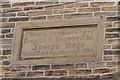
Almshouses Sign, Ivanhoe Road (formerly Ivy Road), Stannington, Sheffield
To view the Almshouses ... see ...
Image
Image: © Terry Robinson
Taken: 14 Jan 2009
0.11 miles
4
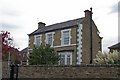
Detached House, Carlby Road, Sheffield
Not sure when but this road has changed from Carr Road to Carlby Road sometime in the last 100 years.
Image: © Terry Robinson
Taken: 29 Oct 2008
0.13 miles
5

Critter Sitter by The Anvil, Wood Lane, Stannington, Sheffield
Image: © Terry Robinson
Taken: 29 Oct 2008
0.14 miles
6
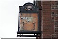
Pub Sign, The Anvil Pub, Stannington Road, Sheffield
Image: © Terry Robinson
Taken: 29 Oct 2008
0.14 miles
7
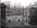
Mousehole Forge (Entrance Gates), Malin Bridge, Sheffield - 1
There has been a forge on this site since the 17th century ... http://www.mouseholeforge.com/ ... currently it is being converted into living accommodation. The forge was famous the world over for the quality and range of Anvils it produced and exported. The nearby pub is aptly named ... Image Image Image
Image: © Terry Robinson
Taken: 14 Jan 2009
0.15 miles
8

The Anvil Pub, Stannington Road, Sheffield
A pub, with this name, on the corner of Wood lane and stannington Road, is shown on the 1905 OS map of this area. It takes its name from the nearby Mousehole Forge, which was famous, worldwide, for the quality and range of anvils it produced. Image Image
Image: © Terry Robinson
Taken: 29 Oct 2008
0.15 miles
9
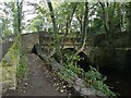
Bridge over River Rivelin
Near Malin Bridge in Sheffield
Image: © Stephen Ostler
Taken: 3 Oct 2021
0.16 miles
10

Former Gateway to Woodville House, Wood Lane, Malin Bridge, Sheffield
Woodville House has long gone, with industrial units on the site ... but these gates still (just) bear the name. Image Image
Image: © Terry Robinson
Taken: 29 Oct 2008
0.16 miles