IMAGES TAKEN NEAR TO
Linaker Road, SHEFFIELD, S6 5DS
Introduction
This page details the photographs taken nearby to Linaker Road, S6 5DS by members of the Geograph project.
The Geograph project started in 2005 with the aim of publishing, organising and preserving representative images for every square kilometre of Great Britain, Ireland and the Isle of Man.

There are currently over 7.5m images from over14,400 individuals and you can help contribute to the project by visiting https://www.geograph.org.uk
Image Map
Images are licensed for reuse under creativecommons.org/licenses/by-sa/2.0
Notes
- Clicking on the map will re-center to the selected point.
- The higher the marker number, the further away the image location is from the centre of the postcode.
Image Listing (66 Images Found)
Images are licensed for reuse under creativecommons.org/licenses/by-sa/2.0
Image
Details
Distance
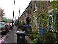
1
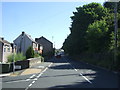
Bole Hill Road, Sheffield
Looking north east.
Image: © JThomas
Taken: 30 Jun 2018
0.06 miles
2
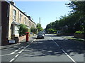
Bole Hill Road, Sheffield
Looking north east showing position of Postbox No. S6 751.
See Image] for postbox.
Image: © JThomas
Taken: 30 Jun 2018
0.07 miles
3
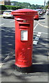
George VI postbox on Bole Hill Road, Sheffield
Postbox No. S6 751.
See Image] for context.
Image: © JThomas
Taken: 30 Jun 2018
0.08 miles
4
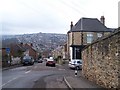
Rivelin Street, Walkley, Sheffield
Second only to Blake Street as the steepest street in Sheffield ... maybe! Certainly it is very steep. Thrush Street runs off to the right. Hollins Lane is in the distance climbing up to Deer Park View flats and Stannington. Image
Image: © Terry Robinson
Taken: 15 Feb 2009
0.09 miles
6
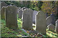
The Jewish Cemetery on Waller Road, Walkley
Image: © Bob Heron
Taken: 15 Nov 2008
0.11 miles
8

Bus at Tinker Lane terminus, Walkley
A bus waits in the small turning area off Tinker Lane, Walkley, before returning to Sheffield city centre.
Image: © Richard Vince
Taken: 24 Apr 2012
0.13 miles
9

Bottom of Tinker Lane, Walkley
The bottom of Tinker Lane, Walkley, near to where it meets Bole Hill Road. The 95 bus route, which arrives from Sheffield city centre via Bole Hill Road, terminates here (see also Image). Due to the sloping topography of the area, no turning circle is provided. Instead, buses approach past the flats and continue to where the photographer is standing (this is a dead end; only the right hand half of the road continues), then reverse to where the bus in this picture is standing to serve the bus stop before turning hard right to return from whence they came.
Image: © Richard Vince
Taken: 24 Apr 2012
0.13 miles
10
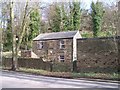
The Lodge, Rivelin Valley Road, Sheffield - 1
The Lodge ... a building possibly linked to the nearby Cemetery Image
Image: © Terry Robinson
Taken: 24 Mar 2009
0.14 miles