IMAGES TAKEN NEAR TO
Findon Crescent, SHEFFIELD, S6 4WL
Introduction
This page details the photographs taken nearby to Findon Crescent, S6 4WL by members of the Geograph project.
The Geograph project started in 2005 with the aim of publishing, organising and preserving representative images for every square kilometre of Great Britain, Ireland and the Isle of Man.

There are currently over 7.5m images from over14,400 individuals and you can help contribute to the project by visiting https://www.geograph.org.uk
Image Map
Images are licensed for reuse under creativecommons.org/licenses/by-sa/2.0
Notes
- Clicking on the map will re-center to the selected point.
- The higher the marker number, the further away the image location is from the centre of the postcode.
Image Listing (16 Images Found)
Images are licensed for reuse under creativecommons.org/licenses/by-sa/2.0
Image
Details
Distance
1
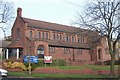
Malin Bridge Primary School, Sheffield
The school is centre frame. Dykes Lane runs to the left of it. In the background are the chimneys of the Abbey Stainless Steel Co. Ltd., at Beeley Wood Lane.
Image: © Dave Hitchborne
Taken: 26 Aug 2008
0.12 miles
3

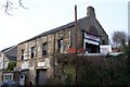
Loxley Motors, Malin Bridge, Sheffield - 1
Loxley Motors is based in the former St Marks Methodist Chapel ... St Marks was opened in 1834 and enlarged in 1870, and again in 1898. A replacement Chapel was opened in, nearby, Dykes Lane in 1904 ... and this building was then used as a Sunday School for a number of years. Eventually the Sunday School also moved to new premises and the Chapel was sold off. Image
Image: © Terry Robinson
Taken: 14 Jan 2009
0.15 miles
4
Loxley Motors, Malin Bridge, Sheffield - 2
As seen in this view, the former Chapel was a two-storey building, with access to the upper level from Wisewood Lane, and access to the lower levels from Loxley Road. Image
Image: © Terry Robinson
Taken: 14 Jan 2009
0.15 miles
5
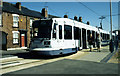
Malinbridge tram terminus
Malinbridge is the westernmost extremity of the Sheffield tram network.
Image: © Stephen McKay
Taken: Unknown
0.17 miles
6
St Polycarp's Church, Malin Bridge, Sheffield
This fine church opened in 1934. http://www.stpolycarpchurch.org.uk/
Image: © Terry Robinson
Taken: 14 Jan 2009
0.17 miles
7
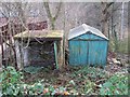
Disused Garages, Loxley Road, Malin Bridge, Sheffield
Image: © Terry Robinson
Taken: 14 Jan 2009
0.17 miles
8

Honeysuckle Cottage, Loxley Road, Malin Bridge, Sheffield
I presume that there is some, somewhere nearby!
Image: © Terry Robinson
Taken: 14 Jan 2009
0.18 miles
9

Houses at Malin Bridge
Late Victorian terrace facing into Loxley Road.
Image: © Alan Murray-Rust
Taken: 27 Mar 2012
0.20 miles
10
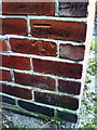
Benchmark on #202 Dykes Lane
Ordnance Survey cut mark benchmark described on the Bench Mark Database at http://www.bench-marks.org.uk/bm36715
Image: © Roger Templeman
Taken: 2 Feb 2011
0.21 miles