IMAGES TAKEN NEAR TO
Clarence Court, SHEFFIELD, S6 4PZ
Introduction
This page details the photographs taken nearby to Clarence Court, S6 4PZ by members of the Geograph project.
The Geograph project started in 2005 with the aim of publishing, organising and preserving representative images for every square kilometre of Great Britain, Ireland and the Isle of Man.

There are currently over 7.5m images from over14,400 individuals and you can help contribute to the project by visiting https://www.geograph.org.uk
Image Map
Images are licensed for reuse under creativecommons.org/licenses/by-sa/2.0
Notes
- Clicking on the map will re-center to the selected point.
- The higher the marker number, the further away the image location is from the centre of the postcode.
Image Listing (133 Images Found)
Images are licensed for reuse under creativecommons.org/licenses/by-sa/2.0
Image
Details
Distance
1
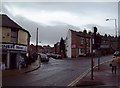
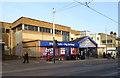
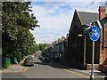
Hillsborough Street Scene
Clarence Road and Dykes Hall Road viewed here from Middlewood Road on a drizzly Wednesday in late February.
Image: © Jonathan Clitheroe
Taken: 23 Feb 2011
0.02 miles
2
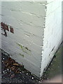
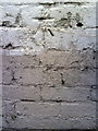
Benchmark on the south side of Minto Road Dental Care
Ordnance Survey cut mark benchmark described on the Bench Mark Database at http://www.bench-marks.org.uk/bm36704
Image: © Roger Templeman
Taken: 2 Feb 2011
0.05 miles
4
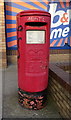
Elizabeth II postbox on Middlewood Road, Sheffield
Outside the Post Office.
Postbox No. S6 351.
See Image] for context.
Image: © JThomas
Taken: 21 Mar 2019
0.05 miles
5
Shop and Post Office on Middlewood Road, Sheffield
Showing position of Postbox No. S6 351.
See Image] for postbox.
Image: © JThomas
Taken: 21 Mar 2019
0.06 miles
6
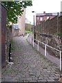
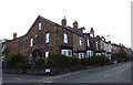
Stony Bank, Walkley, Sheffield
This footpath of many years runs from Walkley Lane up to Woodview Road ... and then on up to Walkley Bank Road - and back down of course!
Image: © Terry Robinson
Taken: 3 May 2010
0.06 miles
7
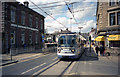
Sheffield tram at Hillsborough
A southbound car of the Sheffield tramway system, destined for Halfway, which is a long way out of the city and nearly at the Derbyshire border.
Image: © Dr Neil Clifton
Taken: 25 Apr 1998
0.07 miles
8
Benchmark on the side of #39 Middlewood Road - Reeds Raines Estate Agents
Ordnance Survey cut mark benchmark above pavement of Roselle Street described on the Bench Mark Database at http://www.bench-marks.org.uk/bm36705
Image: © Roger Templeman
Taken: 2 Feb 2011
0.07 miles
9
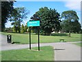
Hawksley Avenue, Hillsborough, Sheffield
Looking southeast from Hillsborough Park towards the city of Sheffield.
Image: © John S Turner
Taken: 15 Jun 2004
0.07 miles
10
Hillsborough Park
The House and park cover 20 hectares and are now owned by Sheffield city council. Part of Hillsborough House can just be seen through the trees. Photo taken from near to the southern entrance to the park.
Image: © John S Turner
Taken: 15 Jun 2004
0.07 miles