IMAGES TAKEN NEAR TO
Roselle Street, SHEFFIELD, S6 4JB
Introduction
This page details the photographs taken nearby to Roselle Street, S6 4JB by members of the Geograph project.
The Geograph project started in 2005 with the aim of publishing, organising and preserving representative images for every square kilometre of Great Britain, Ireland and the Isle of Man.

There are currently over 7.5m images from over14,400 individuals and you can help contribute to the project by visiting https://www.geograph.org.uk
Image Map
Images are licensed for reuse under creativecommons.org/licenses/by-sa/2.0
Notes
- Clicking on the map will re-center to the selected point.
- The higher the marker number, the further away the image location is from the centre of the postcode.
Image Listing (134 Images Found)
Images are licensed for reuse under creativecommons.org/licenses/by-sa/2.0
Image
Details
Distance
1
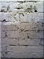
Benchmark on the side of #39 Middlewood Road - Reeds Raines Estate Agents
Ordnance Survey cut mark benchmark above pavement of Roselle Street described on the Bench Mark Database at http://www.bench-marks.org.uk/bm36705
Image: © Roger Templeman
Taken: 2 Feb 2011
0.01 miles
2
Simpkins Sweet Factory, Roselle Street, Sheffield
Simpkins have been making sweets in this factory since 1921 ... mostly they make boiled 'Travel Sweets' packed into tins. Maybe not as famous as, near neighbour, Bertie Bassett, but many locals have found good employment here for years. Image Image
Image: © Terry Robinson
Taken: 24 Mar 2009
0.03 miles
3
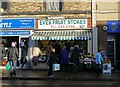
"Eves Fruit Stores", Middlewood Road, Hillsborough
Image: © Neil Theasby
Taken: 30 Dec 2016
0.03 miles
4
Hawthorn Road and Hunter Road, Hillsborough, Sheffield
Hunter Road runs off to the right and gives access to Simpkins Sweet Factory Image ... Hawthorn Road is in the foreground. Note that the first doorway - just to the right of the white shop window and behind the truck - is marked as having an address in Hawthorn Road even though it is round the corner from that street.
Image: © Terry Robinson
Taken: 19 Mar 2009
0.04 miles
5
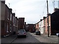
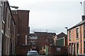
Roselle Street, Hillsborough, Sheffield
Roselle Street - formerly Rose Street* - is only a short cobbled street, with 7 or 8 houses on each side, but it does lead to the Simpkins Sweet Factory. *The name was changed when Hillsborough became part of Sheffield City, where there was already a Rose Street. Image
Image: © Terry Robinson
Taken: 24 Mar 2009
0.04 miles
6
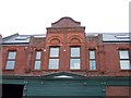
Co-op Shop Detail, Hillsborough Place, Hillsborough
Just suiperb ... nothing as good as this at Meadowhall!
For more information about the branch … see …
Image
See also …
Image
Image
Image: © Terry Robinson
Taken: 19 Mar 2009
0.04 miles
7
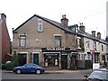
Taplin Chippy, Taplin Road Hillsborough, Sheffield
... and did they smell good whilst taking this picture? ... you bet your sweet bippy they did! (That gives my age away!!!)
Image: © Terry Robinson
Taken: 19 Mar 2009
0.04 miles
8
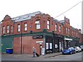
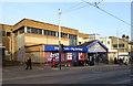
Brightside & Carbrook Co-op Branch 15 (Former), Taplin Road, Hillsborough, Sheffield - 1
A fine example of a 'local' Co-op shop on the corner of Taplin Road
and Hillsborough Place ... now being used for other businesses.
Corrected and Updated in February 2014 following confirmation on Picture Sheffield
This branch - number 15 - was originally part of the Brightside & Carbrook Co-Operative
Society, which in the 1980s merged with the Sheffield & Ecclesall Co-Operative Society
and was re-named - the more logical - Sheffield Co-operative Society.
See also …
Image
Image
Image
Image: © Terry Robinson
Taken: 19 Mar 2009
0.04 miles
9
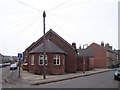
Hillsborough Baptist Church Hall, Hillsborough, Sheffield - 1
Not far from the Baptist Church, on the corner of Hawthorn Road and Hunter Road is the Baptist Church Hall. The phone lines look like a star on high ... well, perhaps not. Image Image
Image: © Terry Robinson
Taken: 19 Mar 2009
0.04 miles
10
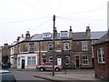
Shop and Post Office on Middlewood Road, Sheffield
Showing position of Postbox No. S6 351.
See Image] for postbox.
Image: © JThomas
Taken: 21 Mar 2019
0.05 miles