IMAGES TAKEN NEAR TO
Wynyard Road, SHEFFIELD, S6 4GD
Introduction
This page details the photographs taken nearby to Wynyard Road, S6 4GD by members of the Geograph project.
The Geograph project started in 2005 with the aim of publishing, organising and preserving representative images for every square kilometre of Great Britain, Ireland and the Isle of Man.

There are currently over 7.5m images from over14,400 individuals and you can help contribute to the project by visiting https://www.geograph.org.uk
Image Map
Images are licensed for reuse under creativecommons.org/licenses/by-sa/2.0
Notes
- Clicking on the map will re-center to the selected point.
- The higher the marker number, the further away the image location is from the centre of the postcode.
Image Listing (121 Images Found)
Images are licensed for reuse under creativecommons.org/licenses/by-sa/2.0
Image
Details
Distance
1
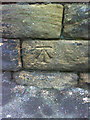
Benchmark on wall opposite #167 Dykes Hall Road
Ordnance Survey cut mark benchmark described on the Bench Mark Database at http://www.bench-marks.org.uk/bm36718
Image: © Roger Templeman
Taken: 2 Feb 2011
0.04 miles
2
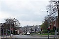
Dykes Hall Road Traffic Lights, Wadsley, Sheffield
The continuation of Dykes Hall Road leads down the hill to Hillsborough. In the distance are houses in Walkley and in the far distance you can just see the top of the University Arts Tower http://www.geograph.org.uk/photo/1114055.
Image: © Terry Robinson
Taken: 30 Apr 2008
0.05 miles
3
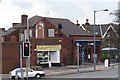
The Honey Pot and Be... Be... Be... Betting Shop, Wadsley, Sheffield
On the other side of the traffic lights is the Beehive Pub ... which, I'm sure, inspired the name of this Sandwich Shop. The Betting Shop is ... just a betting shop ... which is (probably) a hive of activity on match days when Sheffield Wednesday are at home. Image
Image: © Terry Robinson
Taken: 30 Apr 2008
0.06 miles
4
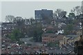
The Arts Tower from Wadsley, Sheffield
The road climbing the hill is Walkley Lane ... with the top of the University Arts Tower in the background. Image
Image: © Terry Robinson
Taken: 30 Apr 2008
0.07 miles
5
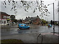
Dykes Hall Road and Far Lane
Road junction with shops; a chippy, nail repair centre and a Tesco.
Image: © Peter Barr
Taken: 10 Oct 2011
0.07 miles
6
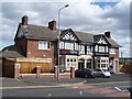
Tesco Express - formerly The Beehive - Dykes Hall Road, Wadsley, Sheffield
The former Beehive Pub has been converted - nicely, one must say - into a Tesco Express ... good news for all locals except for the Convenience Store opposite. For a view of The Beehive, see ... Image
Image: © Terry Robinson
Taken: 21 Sep 2011
0.10 miles
7
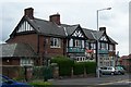
The Beehive, Dykes Hall Road, Wadsley, Sheffield
Next door to The Beehive is the Honey Pot Sandwich Shop ... nice one! Image ... Three years later this pub has been converted into a Tesco Express ... I suppose that's progress! See ... Image
Image: © Terry Robinson
Taken: 30 Apr 2008
0.10 miles
8
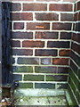
Benchmark on The Beehive pub, Dykes Hall Road
Ordnance Survey cut mark benchmark described on the Bench Mark Database at http://www.bench-marks.org.uk/bm36717
Image: © Roger Templeman
Taken: 2 Feb 2011
0.10 miles
9
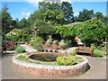
Hillsborough
Part of the Hillsborough Disaster Memorial Garden. Peacefully located in Hillsborough Park with its own access from Middlewood Road.
Image: © John S Turner
Taken: 15 Jun 2004
0.11 miles
10
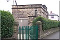
Electricity Sub-Station on Far Lane, Hillsborough
This is how all Sub-Stations should look !
Image: © Terry Robinson
Taken: 16 Mar 2008
0.12 miles