IMAGES TAKEN NEAR TO
Far Lane, SHEFFIELD, S6 4FA
Introduction
This page details the photographs taken nearby to Far Lane, S6 4FA by members of the Geograph project.
The Geograph project started in 2005 with the aim of publishing, organising and preserving representative images for every square kilometre of Great Britain, Ireland and the Isle of Man.

There are currently over 7.5m images from over14,400 individuals and you can help contribute to the project by visiting https://www.geograph.org.uk
Image Map
Images are licensed for reuse under creativecommons.org/licenses/by-sa/2.0
Notes
- Clicking on the map will re-center to the selected point.
- The higher the marker number, the further away the image location is from the centre of the postcode.
Image Listing (205 Images Found)
Images are licensed for reuse under creativecommons.org/licenses/by-sa/2.0
Image
Details
Distance
1
No Entry Now, Far Lane, Hillsborough, Sheffield
Image: © Terry Robinson
Taken: 10 Nov 2008
0.01 miles
2
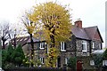
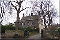
Thorn Lea, Far Lane, Hillsborough, Sheffield
One of Hillsborough's superb 'big' houses. Far Lane Surgery is in the background - built in part of Thorn Lea's grounds. Image Image
Image: © Terry Robinson
Taken: 10 Nov 2008
0.01 miles
3
Wadsley Hall on Far Lane, Hillsborough
Image: © Terry Robinson
Taken: 16 Mar 2008
0.03 miles
4
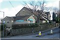
Far Lane, Hillsborough, Sheffield
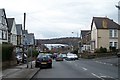
This view shows the junction of Wadsley Lane and - running off up the hill - Far Lane. The Buildings, from the left, are Far Lane Pharmacy, Far Lane Surgery and a 'big' house named Thorn Lea. Thorn Lea is shown on the 1902 Hillsborough map, so is already over 100 years old. The Pharmacy and Surgery are much newer and have been built in part of Thorn Lea's original gardens. Image Image
Image: © Terry Robinson
Taken: 6 Mar 2009
0.04 miles
5
Wadsley Lane, Hillsborough
Sheffield Wednesday's Owlerton Stadium is at the bottom of the hill.
Image: © Terry Robinson
Taken: 16 Mar 2008
0.04 miles
6
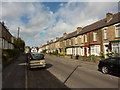
Dixon Road
Terraced houses in the Hillsborough district of Sheffield.
Image: © Peter Barr
Taken: 5 Oct 2011
0.05 miles
7
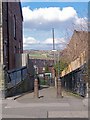
Footpath from Wadsley Lane to Carlton Road - Part 1, Sheffield
This footpath, which gives access from the Wadsley area to the United Reformed Church, 'dog legs' in the middle. Birley Edge is visible in the far distance. Image Image
Image: © Terry Robinson
Taken: 6 Mar 2009
0.05 miles
8
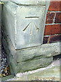
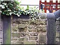
Benchmark on #78 Wadsley Road
Ordnance Survey cut mark benchmark described on the Bench Mark Database at http://www.bench-marks.org.uk/bm36706
Image: © Roger Templeman
Taken: 2 Feb 2011
0.05 miles
9
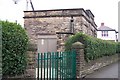
Electricity Sub-Station on Far Lane, Hillsborough
This is how all Sub-Stations should look !
Image: © Terry Robinson
Taken: 16 Mar 2008
0.06 miles
10
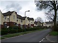
Sutton Estate Houses - 2
Image: © Terry Robinson
Taken: 30 Apr 2008
0.06 miles