IMAGES TAKEN NEAR TO
Wadsley Lane, SHEFFIELD, S6 4ED
Introduction
This page details the photographs taken nearby to Wadsley Lane, S6 4ED by members of the Geograph project.
The Geograph project started in 2005 with the aim of publishing, organising and preserving representative images for every square kilometre of Great Britain, Ireland and the Isle of Man.

There are currently over 7.5m images from over14,400 individuals and you can help contribute to the project by visiting https://www.geograph.org.uk
Image Map (Loading...)


Getting Data...Please wait
Leaflet Map data © OpenStreetMap
Images are licensed for reuse under creativecommons.org/licenses/by-sa/2.0
Notes
- Clicking on the map will re-center to the selected point.
- The higher the marker number, the further away the image location is from the centre of the postcode.
Image Listing (157 Images Found)
Images are licensed for reuse under creativecommons.org/licenses/by-sa/2.0
Image
Details
Distance
1

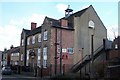
Open all hours on Wadsley Lane!
Shouldn't this be Arkwrights?
Image: © Terry Robinson
Taken: 29 Mar 2008
0.01 miles
2
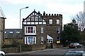
Corner House and Tower from Wadsley Lane
Image: © Terry Robinson
Taken: 29 Mar 2008
0.04 miles
3
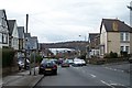
Wadsley Lane, Hillsborough
Sheffield Wednesday's Owlerton Stadium is at the bottom of the hill.
Image: © Terry Robinson
Taken: 16 Mar 2008
0.04 miles
4
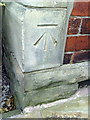
Benchmark on #78 Wadsley Road
Ordnance Survey cut mark benchmark described on the Bench Mark Database at http://www.bench-marks.org.uk/bm36706
Image: © Roger Templeman
Taken: 2 Feb 2011
0.04 miles
5
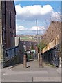
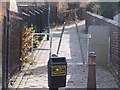
Footpath from Wadsley Lane to Carlton Road - Part 1, Sheffield
This footpath, which gives access from the Wadsley area to the United Reformed Church, 'dog legs' in the middle. Birley Edge is visible in the far distance. Image Image
Image: © Terry Robinson
Taken: 6 Mar 2009
0.04 miles
6
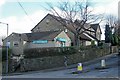
United Reformed Church, Carlton Road, Wadsley, Sheffield
Built in 1910 and still in fine order ... and (hopefully) organising some Centenary Celebrations next year. To one side is a footpath leading through to Wadsley Lane which makes sense of the 'Wadsley' address. Image Image Image Image
Image: © Terry Robinson
Taken: 6 Mar 2009
0.05 miles
7
Footpath from Carlton Road to Wadsley Lane, Sheffield
Image: © Terry Robinson
Taken: 6 Mar 2009
0.05 miles
8
Far Lane, Hillsborough, Sheffield
This view shows the junction of Wadsley Lane and - running off up the hill - Far Lane. The Buildings, from the left, are Far Lane Pharmacy, Far Lane Surgery and a 'big' house named Thorn Lea. Thorn Lea is shown on the 1902 Hillsborough map, so is already over 100 years old. The Pharmacy and Surgery are much newer and have been built in part of Thorn Lea's original gardens. Image Image
Image: © Terry Robinson
Taken: 6 Mar 2009
0.05 miles
9
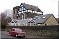
Corner House and Tower from Marlcliffe Road
This house, complete with turreted tower, is situated on the corner of Marlcliffe Road (pronounced for some unknown reason Marcliffe!) and Wadsley Lane. It is now partly used as a Children's Nursery. At the time the picture was taken, there was a 'vintage' Hillman Minx parked outside. Image
Image: © Terry Robinson
Taken: 16 Mar 2008
0.05 miles
10
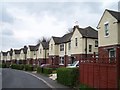
Sutton Estate Houses - 3
Image: © Terry Robinson
Taken: 30 Apr 2008
0.06 miles