IMAGES TAKEN NEAR TO
Worrall Road, SHEFFIELD, S6 4BD
Introduction
This page details the photographs taken nearby to Worrall Road, S6 4BD by members of the Geograph project.
The Geograph project started in 2005 with the aim of publishing, organising and preserving representative images for every square kilometre of Great Britain, Ireland and the Isle of Man.

There are currently over 7.5m images from over14,400 individuals and you can help contribute to the project by visiting https://www.geograph.org.uk
Image Map (51 Images)


Getting Data...Please wait
Leaflet Map data © OpenStreetMap
Images are licensed for reuse under creativecommons.org/licenses/by-sa/2.0
Notes
- Clicking on the map will re-center to the selected point.
- The higher the marker number, the further away the image location is from the centre of the postcode.
Image Listing (51 Images Found)
Images are licensed for reuse under creativecommons.org/licenses/by-sa/2.0
Image
Details
Distance
2
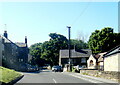
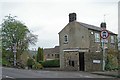
Cottages and Garage on Rural Lane, Wadsley Lane
Rural Lane was formerly Fox Lane!
Image: © Terry Robinson
Taken: 4 Apr 2008
0.06 miles
3
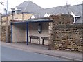
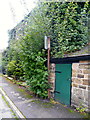
Bus Stop on Worral Road, Middlewood
This Bus Stop, in the wall of the former Middlewood Mental Hospital, was built to serve the Hospital, and would have been used by Staff and Visitors. Now the people living in Wadsley Park Village use it for buses to Sheffield.
Image: © Terry Robinson
Taken: 3 Apr 2008
0.07 miles
4

Wadsley & Loxley Commons ... You're Welcome
Image: © Terry Robinson
Taken: 21 Oct 2008
0.09 miles
5
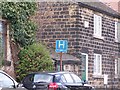
Hospital Sign on Worrall Road, Wadsley, Sheffield
As at March 2008, the sign still exists, but the hospital has been demolished for at least two years and replaced by Wadsley Park Village housing estate.
... Update in August 2012 ...
Four years later and the sign is still here - albeit hidden.
As stated earlier, the hospital no longer exists and actually closed in 1996.
See ...
Image
Image
Image
Update in March 2014
The sign has been removed
Image: © Terry Robinson
Taken: 29 Mar 2008
0.10 miles
6
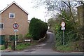
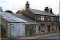
Well Lane, viewed from Worrall Road, Wadsley
Image: © Terry Robinson
Taken: 26 Apr 2008
0.10 miles
7
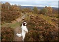
Viewpoint on Wadsley Common
Upland heath area and access land which, given its location, is hugely popular with dog-walkers.
Image: © Jonathan Clitheroe
Taken: 10 Nov 2016
0.11 miles
8
Well Lane, viewed from Rural Lane, Wadsley
This small and narrow road leads from Rural Lane to Worrall Road, in Wadsley. Traffic is restricted in an effort to stop vehicles using this road as a shortcut. Image]
Image: © Terry Robinson
Taken: 26 Apr 2008
0.11 miles
9
What Sign? ... This Sign! ... Worrall Road, Wadsley, Sheffield
For more information ... see ...
Image ... from 2008
... and from 2012 ...
Image
Image
Update in March 2014
The sign has been removed
Image: © Terry Robinson
Taken: 26 Aug 2012
0.11 miles
10

Wadsley & Loxley Commons ... This Way Please
Image: © Terry Robinson
Taken: 21 Oct 2008
0.12 miles