IMAGES TAKEN NEAR TO
Otley Walk, SHEFFIELD, S6 3PY
Introduction
This page details the photographs taken nearby to Otley Walk, S6 3PY by members of the Geograph project.
The Geograph project started in 2005 with the aim of publishing, organising and preserving representative images for every square kilometre of Great Britain, Ireland and the Isle of Man.

There are currently over 7.5m images from over14,400 individuals and you can help contribute to the project by visiting https://www.geograph.org.uk
Image Map
Images are licensed for reuse under creativecommons.org/licenses/by-sa/2.0
Notes
- Clicking on the map will re-center to the selected point.
- The higher the marker number, the further away the image location is from the centre of the postcode.
Image Listing (186 Images Found)
Images are licensed for reuse under creativecommons.org/licenses/by-sa/2.0
Image
Details
Distance
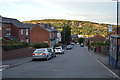
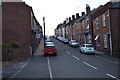
3
Burgoyne Road
The view from Burgoyne Road showing the Neepsend gasometer and the dry ski slope at Parkwood Springs.
Image: © Martin Speck
Taken: 4 Feb 2009
0.02 miles
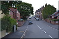
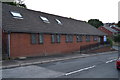
5
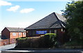
Harold Street Medical Centre, Harold Street, Walkley, Sheffield - 2
See also ...
Image
Image: © Terry Robinson
Taken: 4 Sep 2012
0.04 miles
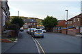
6
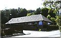
Harold Street Medical Centre, Harold Street, Walkley, Sheffield - 1
See also ...
Image
Image: © Terry Robinson
Taken: 7 Sep 2012
0.04 miles