IMAGES TAKEN NEAR TO
Birkendale View, SHEFFIELD, S6 3NN
Introduction
This page details the photographs taken nearby to Birkendale View, S6 3NN by members of the Geograph project.
The Geograph project started in 2005 with the aim of publishing, organising and preserving representative images for every square kilometre of Great Britain, Ireland and the Isle of Man.

There are currently over 7.5m images from over14,400 individuals and you can help contribute to the project by visiting https://www.geograph.org.uk
Image Map
Images are licensed for reuse under creativecommons.org/licenses/by-sa/2.0
Notes
- Clicking on the map will re-center to the selected point.
- The higher the marker number, the further away the image location is from the centre of the postcode.
Image Listing (97 Images Found)
Images are licensed for reuse under creativecommons.org/licenses/by-sa/2.0
Image
Details
Distance
2
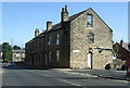
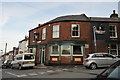
Gates and Graffiti on Daniel Hill Street, Walkley, Sheffield
Image: © Terry Robinson
Taken: 4 Sep 2012
0.12 miles
3
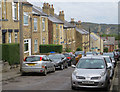
Cromwell Street, Sheffield
Residential street in the Walkley area of the city, looking down in the direction of Walkley Street
Image: © Paul Harrop
Taken: 8 Oct 2016
0.12 miles
4
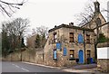
Former St Joseph's House Site, Walkley, Sheffield
The former St Joseph's House lodge is currently home to The Lodge House Natural Health Practice and the former chapel behind it now forms part of a Buddhist community. The area of the city occupied by The University of Sheffield lies 4-5 minutes ahead, by car.
Image: © David Hallam-Jones
Taken: 19 Feb 2018
0.13 miles
5
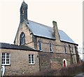
Former St Joseph's House, Walkley, Sheffield
In 1861, a Roman Catholic reformatory was opened here in what at first sight seems to be an extension to this former chapel. In fact the chapel - with school rooms beneath it - was not built until 1872. The residential reformatory was opened here in this former boarding school building, "Howard House" and renamed St Joseph’s. Later, between 1887-1931, the premises became a residential “Industrial School for Roman Catholic Girls”. Still later, after a period of closure, it reopened in 1934 as St Joseph’s House for Mentally Handicapped Women and Girls, receiving referrals from across Gt. Britain. By this time additional buildings had been added on site. In 1971 its management was assumed by the Sheffield Health Board, although the Sisters of Charity continued to staff it. In 1974 however, the nuns withdraw their services at the time that the more stringent regulations relating to meeting the educational needs of individuals with learning difficulties came into being. These facilities closed permanently in 1983 and these buildings are currently occupied by a Buddhist community. (See also: http://saintjosephshome.weebly.com/download-the-booklet.html)
Image: © David Hallam-Jones
Taken: 19 Feb 2018
0.13 miles
8
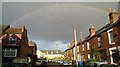
Rainbow over Boyce Street
Rainbow over Boyce Street/Daniel Hill Mews.
Image: © GraceS
Taken: 28 Oct 2013
0.14 miles
9
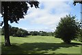
Football Pitch, Ruskin Park, Walkley, Sheffield
For more information about Ruskin Park ... see ...
Image
Image: © Terry Robinson
Taken: 7 Sep 2012
0.14 miles
10
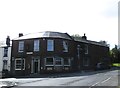
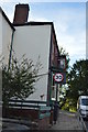
The Blake Hotel, Blake Street, Walkley, Sheffield - September 2012
Compare this view with that in February 2009, when the pub was closed ...
Image
... now open for business and with a slight change to the name.
See also ...
Image
Image
This view of pub featured in THE FULL MONTY
Image: © Terry Robinson
Taken: 7 Sep 2012
0.15 miles